Forecast for the Moab Area Mountains

Issued by Eric Trenbeath on
Monday morning, December 26, 2022
Monday morning, December 26, 2022
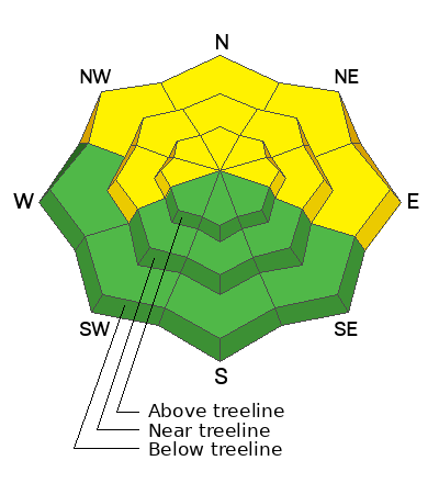
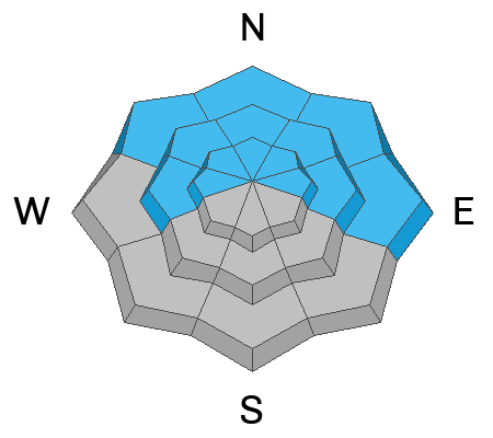
A MODERATE danger for human triggered avalanches failing on a buried persistent weak layer exists on slopes that face W-N-E. The danger is greatest on steep northerly aspects near treeline and above where wind drifted snow has built thick slabs and added more stress to this buried weak layer. Dangerous, human triggered avalanches 2'-4' deep remain possible and slopes steeper than 30 degrees should be avoided in these areas. Most south facing terrain has generally LOW danger.

Low
Moderate
Considerable
High
Extreme
Learn how to read the forecast here
 Special Announcements
Didn’t get what you want for Christmas? Do your loved ones simply give you money for the holidays and say “Go buy something for yourself?” Support the UAC and get a great gift for yourself or your loved one at our Holiday Auction. The auction closes at 8:00 PM MT on January 2, 2023.
Road Conditions: The road is snowpacked and slick. AWD and good tires are required.
Grooming: LUNA groomed all trails on Friday. Thanks John!
 Weather and Snow
24 Hour Snow 0" 72 Hour Snow 1" Season Total Snow 80" Base Depth at Gold Basin 40"
Winds on Pre Laurel Peak NW 5-10 G25 Temp 22F
Weather
After a dry and mostly sunny weekend, today will begin a much anticipated transition. NW flow aloft will shift to SW later in the day ahead of a low pressure system brewing off the West Coast. We should see mostly sunny skies today with a few clouds here and there. High temps will be in the low 30's. Tonight brings increasing clouds and SW winds. Tuesday will see cloudy skies, breezy SW winds gusting into the 30 mph range, and a developing chance for snow throughout the day. Things should kick in Tuesday night and last through Wednesday. With a favorable jet stream location, ample moisture, and strong SW flow, we are in a good position to see some snow with 1'-2' possible by Thursday. A stormy pattern looks to continue into the new year.
The snow surface has taken hit over the past several days and you can expect to find a combination of crusted, scoured, and alternately wind loaded slopes near and above treeline. You can still find nice, settled powder in shady, sheltered locations. Recent wind loading has kept the pressure on a buried persistent weak layer of faceted snow, particularly on steep, northerly aspects near treeline and above, and human triggered avalanches 2'-4' deep remain possible in these areas.
If you're getting out in the backcountry please let us know what you are seeing by submitting an observation . Here are the most recent observations.
Snowpack and Weather Data
Gold Basin Storm Stake (10,000')
Gold Basin SNOTEL site (10,000')
Wind Station on Pre-Laurel Peak (11,400')
 Recent Avalanches
The last observed avalanche was on Thursday, Dec 22. Here is a complete list of avalanches in the La Sals.
Avalanche Problem #1
Persistent Weak Layer
Type
Location

Likelihood
Size
Description
A persistent weak layer of faceted snow that developed during the cold dry period in mid November still exists on W-N-E aspects. Obvious signs of instability such as collapsing and cracking are not present but a poor snowpack structure, consisting of strong snow over weak snow, still exists. Slopes facing NW-N-E, near treeline and above, are the most suspect. In these areas wind drifted snow has built thick slabs on top of the weak layer. With significant snow in the forecast this week, deep and dangerous avalanches, failing on this weak layer will become increasingly more likely.
Additional Information
For a personal account of a human triggered avalanche, failing on a persistent weak layer during a period of moderate danger, see Eric's blog post here.
General Announcements
This forecast is from the U.S.D.A. Forest Service, which is solely responsible for its content. This forecast describes general avalanche conditions and local variations always occur. This forecast will be updated by 7:30 tomorrow morning.


