Check out our Holiday Auction

Forecast for the Logan Area Mountains

Toby Weed
Issued by Toby Weed on
Wednesday morning, December 21, 2022
A powerful winter storm with heavy snowfall and extensive drifting will overload slopes with buried persistent weak layers and cause the backcountry avalanche danger to rise rapidly during the day. Dangerous avalanche conditions already exist this morning on drifted upper and mid elevation slopes, and the danger will rise to HIGH in many areas by afternoon. Large and long running natural and human triggered avalanches will become likely.
  • People should stay off of and out from under drifted slopes steeper than 30°
  • Avoid travel in avalanche terrain and stay well clear of obvious or historic avalanche run-outs.
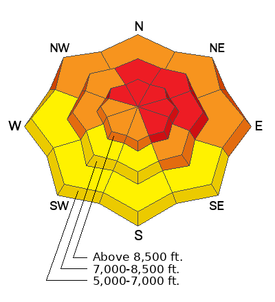
Low
Moderate
Considerable
High
Extreme
Learn how to read the forecast here
Avalanche Warning
What: The avalanche danger for the warning area will rise to HIGH later today.
When: In effect from 6am MST this morning to 6am MST Thursday
Where: For the Bear River Range in Northern Utah and Southeast Idaho
Impacts: Heavy snow and drifting snow will overload slopes with widespread buried persistent weak layers and cause the avalanche danger to rise rapidly. The storm will create HIGH avalanche danger in the backcountry today, with both natural and human triggered avalanches becoming likely.
People should stay off of and out from under drifted slopes steeper than 30 degrees.
Special Announcements
  • As the end of the year approaches, please consider a donation to the UAC to support avalanche forecasting.
  • We have discounted Beaver Mountain tickets for sale. HERE. Huge thanks to Beaver Mountain for supporting the work we do.
Weather and Snow
The snow from November has become a tricky persistent weak layer plaguing many slopes at all elevations in the Logan Zone. Heavy snowfall and drifting from today's powerful storm will overload slopes with poor snow structure and cause a rapid rise in avalanche danger.

This morning winds from the west- southwest are blowing 30 to 40 mph and gusting into the 50s at the Mount Ogden weather station at Snow Basin. I'm reading 22° F and there is three inches of new snow and 46 inches of total snow at the 8400' Tony Grove Snotel.
Today will be quite stormy, with periods of heavy snow and significant drifting from strong west winds blowing 25 to 35 mph with gusts well above 50 mph possible. 12 to 16 inches of accumulation is likely on upper elevation slopes. The avalanche danger will climb to HIGH by this afternoon as slopes with poor snow structure are overloaded.
Tonight there will be widespread areas of blowing snow and temperatures will drop to around -10° F. Northwest winds will gradually diminish and about an inch of additional accumulation is expected.
Tomorrow will be mostly sunny and cold, with 8500' high temperatures around 7° F, 10 to 15 mph winds from the northwest, and wind chill values as low as -30° F
Recent Avalanches
Natural avalanches were fairly widespread during the stormy weather last week. No new avalanches or avalanche incidents were reported from the weekend.

***See our updated list of observed avalanches from the Logan Zone HERE and from across Utah HERE
Ad
Avalanche Problem #1
Persistent Weak Layer
Type
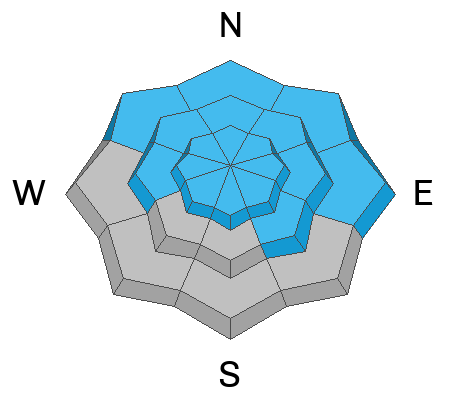
Location
Likelihood
Size
Description
We've found buried layers of sugary snow at all elevations and on slopes facing every direction. In areas where the snow is shallow, less than about 3 feet deep, the basal layers of the snowpack are very loose and sugary. If you get off your sled or skis you sink all the way to the ground and it's pretty easy to get the sled stuck if you sink and spin your track into the bottomless sugary snow. This set up is not good, and conditions will become worse this week as heavy snow and drifting overload slopes plagued by the widespread persistent weak layer.
  • Red Flags indicating a persistent weak layer instability will include audible collapses or whumpfs and shooting cracks, but sometimes no red flags are apparent, and you have to dig down into the snow to find the sugary weak layer.
  • Slab avalanches failing on a buried persistent weak layer could be remotely triggered from a distance, and hopefully not from below.
Avalanche Problem #2
Wind Drifted Snow
Type
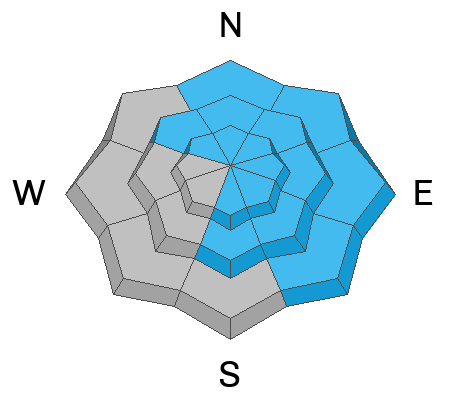
Location
Likelihood
Size
Description
Natural and human triggered avalanches of wind drifted snow are likely in exposed upper and mid elevation terrain. Avalanches of wind drifted snow failing on a buried persistent weak layer could be 2 to 4 feet deep and a few hundred feet wide.
  • Slabs of drifted snow are rapidly building today on the lee side of major ridges, under cornices, and in and around terrain features like sub-ridges, saddles, cliff bands, and gully walls.
  • People should stay off of and out from under all recently drifted slopes in the backcountry steeper than about 30°.
Additional Information
Take the all-new online avalanche courses the UAC built for Know Before You Go or take other online courses listed on the KBYG website (Develop skills -> Online Learning).
Remember, when you leave the ski area boundary, Beaver Mt or Cherry Peak, you are entering the backcountry, and you could trigger dangerous avalanches....
  • Put fresh batteries in your transceiver and inspect your shovel and probe.
  • Practice Companion Rescue with your backcountry partners.
General Announcements
Please submit your observations from the backcountry HERE.
For a list of avalanche classes from the Utah Avalanche Center go HERE
For information on where you can ride your sled or snowbike, check out this map of the winter travel plan for the Tony Grove and Franklin Basin Areas HERE.
This forecast is from the U.S.D.A. Forest Service, which is solely responsible for its content. This forecast describes general avalanche conditions and local variations always occur.