AVALANCHE WARNING!! Tap for info

Forecast for the Logan Area Mountains

Paige Pagnucco
Issued by Paige Pagnucco on
Sunday morning, December 15, 2024
The avalanche danger is CONSIDERABLE due to heavy snowfall and strong winds. Natural avalanches are possible and human-triggered avalanches are likely in drifted, upper-elevation terrain. What's called for today? Careful snowpack evaluation, cautious route-finding, and conservative decision-making. Avoid steep, wind-loaded slopes with weak, faceted snow.
Low
Moderate
Considerable
High
Extreme
Learn how to read the forecast here
Special Avalanche Bulletin
What: Heavy snowfall and drifting by strong winds will cause dangerous avalanche conditions to develop this weekend in the mountains of northern Utah.
When: In effect from 6 am MST this morning through 6 am Monday morning
Where: For the mountains of Northern Utah and Southeastern Idaho, including the Wasatch Range...Bear River Range... and Western Uinta Mountains.
Impacts: Dangerous avalanche conditions will develop on many slopes today. People are likely to trigger avalanches by being on or below slopes steeper than 30 degrees. Avalanches could be triggered remotely (from a distance) or from below. For updated avalanche information, go to www,utahavalanchecenter.org. What to do: Avoid traveling on or underneath steep north-facing terrain at mid and upper elevations in the backcountry. Carry and know how to use avalanche rescue equipment.
Special Announcements
Gear up for the season or score great deals on gifts for loved ones this holiday season while supporting the UAC’s efforts. Your participation directly funds the state's avalanche forecasting, awareness, and education programs. Check out the auction found here!
Weather and Snow
It’s great to see solid snowfall in the mountains, with 6-10 inches so far and more falling as I write. However, the new snow plus consistent strong southwest winds have created dangerous avalanche conditions. With an already weak snowpack, natural avalanches are possible in steep, wind-loaded terrain, and people-triggered avalanches are likely. If you choose to ride in steeper, wind-loaded terrain today, get your shovel out and dig down to ensure there's no underlying layer of weak, sugary, faceted snow. You'll find the best riding conditions in sheltered terrain on slopes less than 30 degrees.
As of 6 a.m. this morning, Tony Grove is showing 26° F, with about 8 inches of new snow from overnight and 26 inches of total snow. Winds on Logan Peak are blowing from the west around 28 mph with gusts in the 40s mph. It's 23° F at Card Canyon with about 24" of total snow, and Paris Peak, a bit chillier, is 19° F with southwesterly winds blowing 20 mph with gusts near 35 mph.
The National Weather Service continues a Winter Weather Advisory (Winter Storm Warning in Idaho) until 3 PM today. Snow continues to fall until about noon, adding a few more inches. Unfortunately, the strong winds last through the day and will continue to move snow and create a chilly wind chill. The 8500' high will be about 24° F, but it will feel much colder due to the wind.
We get a small break tonight into Monday, and then another system moves in with the chance for more snow Monday night into Tuesday.
For more information, visit the UAC weather page here: Weather - Utah Avalanche Center
For Logan-specific weather, go here: Logan Mountain Weather - Utah Avalanche Center
Recent Avalanches
No new avalanches have been reported.
You can read all observations here.
Ad
Avalanche Problem #1
Wind Drifted Snow
Type
Location
Likelihood
Size
Description
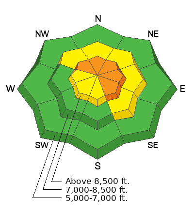
With sustained strong winds and heavy snowfall, natural avalanches are possible and human-triggered avalanches are likely. These could be one to two feet deep, or more in favored areas. We have three red flags already this morning - heavy snowfall, strong winds, and poor snowpack structure. That is enough for me to avoid wind-loaded slopes with preexisting weak snow.
  • Our snowpack is made up of mostly weak, sugary, faceted snow and it will not support the added weight of wind-deposited snow.
  • Cracking and collapsing are signs of unstable snow.
  • A ride in even a small avalanche is especially dangerous due to buried obstacles like rocks, stumps, and downed trees.
Additional Information
Yesterday, Greg G. and Bill B. visited Cutler Ridge (just to our south under Ben Lomond Peak) and found a setup similar to the Logan zone. It is a great example of how wind-loaded snow behaves when it lands on weak, faceted snow.
General Announcements
-National Forest Winter Recreation Travel Maps show where it's open to ride: UWCNF Logan, Ogden LRD Tony Grove, Franklin Basin CTNF Montpelier
-Sign up for forecast region-specific text message alerts. You will receive messages about changing avalanche conditions, watches, and warnings...HERE.
-For all questions on forecasts, education, Know Before You Go, events, online purchases, or fundraising, call 801-365-5522.
-To report an avalanche or submit an observation from the backcountry, go HERE.
-Remember that the Tony Grove Road is not maintained for winter driving. Treacherous snow-covered and icy conditions will be encountered.

This forecast is from the U.S.D.A. Forest Service, which is solely responsible for its content. This forecast describes general avalanche conditions, and local variations always occur.