Check out our Holiday Auction

Forecast for the Logan Area Mountains

Toby Weed
Issued by Toby Weed on
Tuesday morning, November 26, 2024
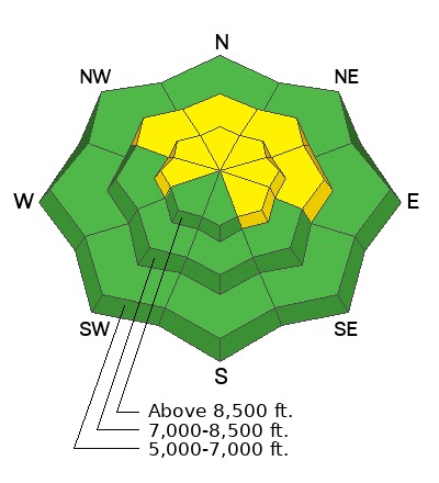
Today, heavy snow and drifting will overload widespread slopes plagued by weak, sugary snow and poor snow structure on upper and mid-elevation slopes in the backcountry, elevating the avalanche danger. The danger is MODERATE, and people could trigger soft slab avalanches of new snow or stiffer slabs of wind-drifted snow on northerly slopes steeper than 30°.
Low
Moderate
Considerable
High
Extreme
Learn how to read the forecast here
Special Announcements
SAVE THE DATES!
Tuesday, December 3 - 21st Annual Pray for Snow fundraiser/party, Cache, Logan Information and tickets available here.
Wednesday, December 4 - USU KBYG (Know Before You Go) Night, USU ARC
Saturday, December 7 - 17th Annual Utah Snow and Avalanche Workshop (USAW) - Information and tickets available here.
Weather and Snow
The National Weather Service has issued a Winter Storm Warning for all the mountains in Utah, including the Logan Zone, with the Bear River Range in far southeast Idaho. Heavy snow is expected. Total snow accumulations of 10-20 inches for the northern Utah mountains. Weak, sugary, or faceted snow from early November is widespread in upper-elevation terrain. Today, people could trigger avalanches in the backcountry. Heavy snowfall will overload slopes with poor snow structure, causing an increase in avalanche danger on upper-elevation slopes steeper than 30°. In exposed terrain, drifting previously formed and is building stiffer wind slabs on the underlying weak snow, and wind slab avalanches are possible. Although there may not be enough snow on many slopes to bury you, a ride over rocks in even a small avalanche could be quite dangerous.
  • The 8500' Tony Grove Snotel reports 28°F and 3 inches of new snow early this morning, with 19 inches of total snow on the ground. It's 26°F at the 8800' UAC Card Canyon weather station, with an inch of new snow and 22" of total snow.
  • Currently at 9700' at the CSI Logan Peak weather station, it's 23°F and the wind is blowing from the west-southwest 20 mph, with overnight gusts around 40 mph. At 9500' on UAC Paris Peak it's 21°F, and winds are from the south-southwest 15 mph with 25 to 30 mph gusts.
  • Today, snow will be heavy at times, with 6 to 10 inches of accumulation possible. 8500' high temperatures will be around 27°F and winds will blow from the west-southwest around 10 mph.
    Tonight, snow, heavy at times, is likely to continue into the late evening, with 3 to 5 additional inches possible. Temperatures will drop to around 17°F, and winds from the northwest will blow 6 to 9 mph.
    Wednesday, light snow is possible in the morning, but it will be partly sunny. Expect high temperatures around 20°F and winds from the west 5 to 7 mph.
For more information, visit the UAC weather page here: Weather - Utah Avalanche Center
For Logan-specific weather go here: Logan Mountain Weather - Utah Avalanche Center
Recent Avalanches
On Sunday, observers reported triggering a few audible collapses or "whumpfs" in north-facing terrain at around 8700' in elevation. These triggered collapses are a red flag indicating unstable snow.
No significant avalanches have been reported yet in the Logan Zone.
Ad
Avalanche Problem #1
Persistent Weak Layer
Type
Location
Likelihood
Size
Description
Heavy snowfall and drifting today will overload slopes plagued by very weak, sugary or faceted snow, elevating the avalanche danger.
  • Avalanches of new snow will become increasingly possible for people to trigger as new snow stacks up.
  • Natural avalanches are possible during periods of particularly heavy snowfall.
  • Avalanches of wind-drifted snow will become easier to trigger and larger as snow is drifted into lee slope avalanche starting zones.
Additional Information
Shallow, early-season conditions exist in the Bear River Range. Keep your speed down, hitting shallowly buried rocks, stumps, or down trees could end your season before it really begins...

The video is from last year, but the message is still good for the early season. Take the time now to check your companion rescue equipment and refresh your skills with backcountry partners...
General Announcements
-National Forest Winter Recreation Travel Maps show where it's open to ride: UWCNF Logan, Ogden LRD Tony Grove, Franklin Basin CTNF Montpelier
-Sign up for forecast region-specific text message alerts. You will receive messages about changing avalanche conditions, watches, and warnings...HERE.
-For all questions on forecasts, education, Know Before You Go, events, online purchases, or fundraising, call 801-365-5522.
-To report an avalanche or submit an observation from the backcountry, go HERE.
-Please continue to submit your observations from the backcountry so we can publish them and keep people informed of what you're seeing out there.

This forecast is from the U.S.D.A. Forest Service, which is solely responsible for its content. This forecast describes general avalanche conditions, and local variations always occur.