Join us at our 2nd Annual Blizzard Ball

Forecast for the Logan Area Mountains

Toby Weed
Issued by Toby Weed on
Monday morning, November 25, 2024
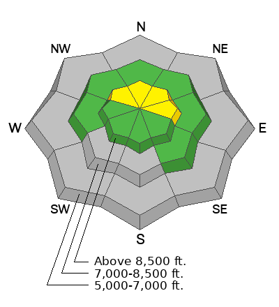
Areas of heightened avalanche conditions exist at upper elevations in the backcountry. The danger is MODERATE, and people could trigger small slab avalanches of wind-drifted snow on slopes steeper than 30° facing northwest, north, and east.
Expect rising danger tomorrow as heavy snowfall will begin to overload widespread slopes with poor snow structure and weak snow.
Low
Moderate
Considerable
High
Extreme
Learn how to read the forecast here
Special Announcements
SAVE THE DATES!
Tuesday, December 3 - 21st Annual Pray for Snow fundraiser/party, Cache, Logan Information and tickets available here.
Wednesday, December 4 - USU KBYG (Know Before You Go) Night, USU ARC
Saturday, December 7 - 17th Annual Utah Snow and Avalanche Workshop (USAW) - Information and tickets available here.
Weather and Snow
Weak, sugary, or faceted snow from earlier in November is widespread in upper-elevation terrain. Today, in places where drifts formed on this weak snow on slopes steeper than 30°, a person could trigger small slab avalanches of wind-drifted snow. Although there's probably not enough snow to bury you, a ride over rocks in even a small avalanche could be quite dangerous.
  • The 8500' Tony Grove Snotel reports 5 inches of new snow from Saturday night, and 17 inches of total snow on the ground. 5 inches of new snow also accumulated at the 8800' UAC Card Canyon weather station, now with 21" of total snow.
  • Currently, the wind is blowing from the southwest 13 mph, with overnight gusts around 22 mph at 9700' at the CSI Logan Peak weather station and from the west-southwest 11 mph with gusts of around 20 mph on Paris Peak.
  • Today will be mostly sunny with 8500' high temperatures around 26°F and light winds from the southwest.
    Tonight, snow is likely late, with 3 to 5 inches possible. Temperatures will rise to around 26°F and winds from the southwest will blow 10 mph.
    Tuesday, snow will be heavy at times, with 8 to 12 inches of accumulation possible. Expect high temperatures around 27°F and winds from the west around 10 mph.
    Tuesday Night, 2 to 4 inches of additional snow possible, temperatures will drop to around 19°F and winds from the west will blow around 10 mph.
For more information, visit the UAC weather page here: Weather - Utah Avalanche Center
For Logan-specific weather go here: Logan Mountain Weather - Utah Avalanche Center
Recent Avalanches
Yesterday, observers reported triggering a few audible collapses or "whumpfs" in north-facing terrain at around 8700' in elevation. These triggered collapses are a red flag indicating unstable snow.
No avalanches have been reported yet in the Logan Zone.
Ad
Avalanche Problem #1
Wind Drifted Snow
Type
Location
Likelihood
Size
Description
Shallow avalanches of stiff, drifted snow (wind slab avalanches) are possible for people to trigger in upper-elevation terrain on slopes steeper than 30°.
Additional Information
Shallow, early-season conditions exist in the Bear River Range. Keep your speed down, hitting shallowly buried rocks, stumps, or down trees could end your season before it really begins...

The video is from last year, but the message is still good for the early season. Take the time now to check your companion rescue equipment and refresh your skills with backcountry partners...
General Announcements
-National Forest Winter Recreation Travel Maps show where it's open to ride: UWCNF Logan, Ogden LRD Tony Grove, Franklin Basin CTNF Montpelier
-Sign up for forecast region-specific text message alerts. You will receive messages about changing avalanche conditions, watches, and warnings...HERE.
-For all questions on forecasts, education, Know Before You Go, events, online purchases, or fundraising, call 801-365-5522.
-To report an avalanche or submit an observation from the backcountry, go HERE.
-Please continue to submit your observations from the backcountry so we can publish them and keep people informed of what you're seeing out there.

This forecast is from the U.S.D.A. Forest Service, which is solely responsible for its content. This forecast describes general avalanche conditions, and local variations always occur.