Join us at our 2nd Annual Blizzard Ball

Forecast for the Logan Area Mountains

Toby Weed
Issued by Toby Weed on
Sunday morning, November 24, 2024
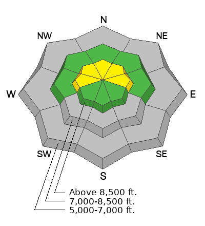
Heightened avalanche conditions exist at upper elevations in the backcountry, the danger is MODERATE, and people could trigger small soft slab avalanches of new snow and/or stiffer wind slab avalanches on slopes steeper than 30° facing west, north, and east. Although there's probably not enough snow to bury you, a ride over rocks in even a small avalanche could be quite dangerous.
Low
Moderate
Considerable
High
Extreme
Learn how to read the forecast here
Special Announcements
SAVE THE DATES!
Tuesday, December 3 - 21st Annual Pray for Snow fundraiser/party, Cache, Logan Information and tickets available here.
Wednesday, December 4 - USU KBYG (Know Before You Go) Night, USU ARC
Saturday, December 7 - 17th Annual Utah Snow and Avalanche Workshop (USAW) - Information and tickets available here.
Weather and Snow
Heavy snowfall and drifting by strong winds elevated avalanche conditions in the backcountry. Weak, sugary, or faceted snow from earlier in November is widespread in upper-elevation terrain. Today, in places where this weak snow exists on slopes steeper than 30°, a person could trigger loose or soft slab avalanches of storm snow and/or small hard slab avalanches of wind-drifted snow.
  • The 8500' Tony Grove Snotel reports 5 inches of new snow in the last 24 hours, with 18 inches of total snow on the ground. I'm also reading 5 inches of new snow at the 8800' UAC Card Canyon weather station, with 22" of total snow.
  • The winds came around from the northwest and diminished significantly overnight. Currently, the wind is blowing from the northwest 18 mph, with overnight gusts around 30 mph at 9700' at the CSI Logan Peak weather station and 15 mph with gusts of around 25 mph on Paris Peak.
  • After a break Sunday afternoon through Monday, storminess will return with the potential for decent additional accumulations in the mountains and winter driving conditions leading up to the Thanksgiving Holiday.
For more information, visit the UAC weather page here: Weather - Utah Avalanche Center
For Logan-specific weather go here: Logan Mountain Weather - Utah Avalanche Center
Shallow, early-season conditions exist in the Bear River Range. Keep your speed down, hitting shallowly buried rocks, stumps, or down trees could end your season before it really begins......
Recent Avalanches
No avalanches have been reported recently in the Logan Zone, but remember, avalanches are most likely during and just after storms on slopes steeper than 30°.
Ad
Avalanche Problem #1
Wind Drifted Snow
Type
Location
Likelihood
Size
Description
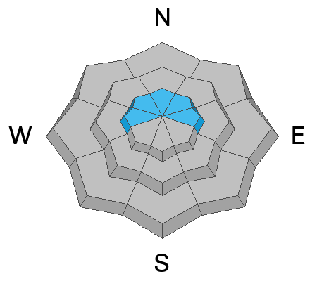
Shallow avalanches of stiff, drifted snow (wind slab avalanches) are possible for people to trigger in upper-elevation terrain on slopes steeper than 30°.
  • What were obvious drifts yesterday are likely buried and hidden today by last night's fresh powder.
  • Hard wind slabs often let people get out on them before releasing like a giant mouse trap.
Avalanche Problem #2
New Snow
Type
Location
Likelihood
Size
Description
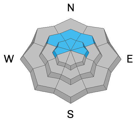
Storm slab and loose avalanches of new snow are possible in the coming days as fresh snow accumulates and drifts on slopes with shallow, very weak snow.
Additional Information
The video is from last year, but the message is still good for the early season. Take the time now to check your companion rescue equipment and refresh your skills with backcountry partners...
General Announcements
-National Forest Winter Recreation Travel Maps show where it's open to ride: UWCNF Logan, Ogden LRD Tony Grove, Franklin Basin CTNF Montpelier
-Sign up for forecast region-specific text message alerts. You will receive messages about changing avalanche conditions, watches, and warnings...HERE.
-For all questions on forecasts, education, Know Before You Go, events, online purchases, or fundraising, call 801-365-5522.
-To report an avalanche or submit an observation from the backcountry, go HERE.
-Please continue to submit your observations from the backcountry so we can publish them and keep people informed of what you're seeing out there.

This forecast is from the U.S.D.A. Forest Service, which is solely responsible for its content. This forecast describes general avalanche conditions, and local variations always occur.