Check out our Holiday Auction

Forecast for the Logan Area Mountains

Toby Weed
Issued by Toby Weed on
Wednesday morning, January 27, 2021
DANGEROUS HUMAN TRIGGERED AVALANCHES ARE BECOMING MORE LIKELY!
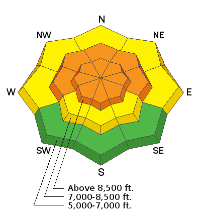
Elevated avalanche conditions exist this morning on steep slopes at all elevations in the Bear River Range, and drifting fresh snow from intensifying south winds will cause the avalanche danger to increase. Dangerous conditions will develop, and today the danger will rise to CONSIDERABLE on steep drifted slopes at upper and mid elevations. People are likely to trigger slab avalanches of wind drifted snow, as well as more dangerous avalanches involving old snow, failing on a widespread buried persistent weak layer.
  • Evaluate snow and terrain carefully and make conservative decisions.
  • Continue to stay off and out from under drifted slopes steeper than about 30 degrees.
Low
Moderate
Considerable
High
Extreme
Learn how to read the forecast here
Avalanche Watch
STRONG WINDS AND HEAVY DENSE SNOWFALL WILL LIKELY CREATE VERY DANGEROUS AVALANCHE CONDITIONS. BOTH HUMAN TRIGGERED AND NATURAL AVALANCHES ARE LIKELY. STAY OFF OF AND OUT FROM UNDER SLOPES STEEPER THAN 30 DEGREES.
Weather and Snow
The 8400' Tony Grove Lake Snotel reports 7 inches of new snow overnight and 44 inches of total snow. There is only 61% of normal Snow Water Equivalent for the date, and the existing snowpack is generally quite shallow across the Logan Zone. South winds picked up overnight and are now blowing 30 mph with gusts around 45 mph at the 9700' CSI Logan Peak weather station. People could trigger dangerous avalanches failing on a widespread buried persistent weak layer, elevated avalanche conditions exist on steep slopes at all elevations, and the danger is increasing...
We went up on Red Pine Ridge Monday and found that the snow is exceptionally shallow, weak, and perhaps on the verge of being unstable on steep slopes in the terrain around Logan Peak. The avalanche danger is increasing across the Logan Zone and we recommend that people continue to avoid and stay out from under slopes steeper than about 30 degrees, and stay well clear of the obvious and historic avalanche paths for a while.

The National Weather Service in Pocatello has issued a fairly long duration Winter Weather Advisory in the Northern Bear River Range for today through Friday night. Today will be cloudy, with a good chance for some more snow this afternoon, with 1 to 3 inches of accumulation forecast. Expect 8500' high temperatures around 23°F, an intensifying south wind (already blowing 30 mph), and wind chill values as low as -9°F. More snow is likely tonight and tomorrow, with 4 to 8 inches of accumulation possible, continued strong south and southwest wind, and temperatures rising to around freezing at upper elevations. Southwest wind will continue and bit more snow is expected on Friday and friday night..
Recent Avalanches
It was an active weekend and active again yesterday in the Wasatch Range, with numerous human triggered avalanches reported. Visit our avalanche list HERE
Observers over the weekend reported a few natural and triggered shallow soft slab and loose avalanches of new snow in the Bear River Range, and yesterday we observed from a distance some natural activity involving new snow in the Adams Corral Area. There was one report of a small remotely triggered avalanche that involved old snow in the Peter Sinks area Sunday. It stepped down to into the faceted snow from December.
Ad
Avalanche Problem #1
Persistent Weak Layer
Type
Location
Likelihood
Size
Description
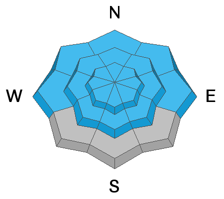
Very weak sugary or faceted snow near the ground is widespread across the region, and people could trigger avalanches where a slab of more cohesive snow has formed on top of the weak snow. A small avalanche overrunning a slope with poor snow structure could cause a larger, more dangerous avalanche. The load of the new snow may be enough in some areas to overload deeper buried persistent weak layers that are widespread across the zone, and large avalanches could result.
  • Avalanches failing on a buried persistent weak layer might be triggered remotely, from a distance, or worse from below!
  • Cracking and collapsing of the snow are a red flag, indicating unstable snow conditions.
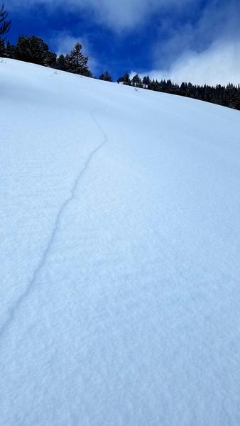
An observer sent in this picture of a long shooting crack that was accompanied by an audible collapse that occurred in low angled terrain in the Garden City Bowls Area yesterday.
These large faceted snow grains make up a nastyburied persistent weak layer that is widespread in the Logan Zone. It is especially prevalent in the Logan Peak Area.
Avalanche Problem #2
Wind Drifted Snow
Type
Location
Likelihood
Size
Description
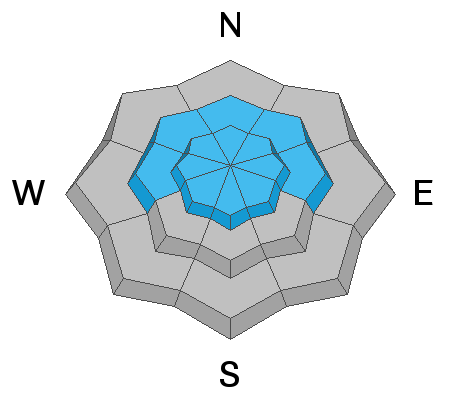
Intensifying south winds today will continue to drift light fresh snow into lee slope avalanche starting zones, cross-load east and west facing slopes, and build drifts and wind slabs on steep upper and mid elevation slopes. Drifting created more cohesive slabs of the light surface snow, people are likely to trigger slab avalanches of wind drifted snow today. South winds will increase and continue to blow tonight and tomorrow, more fresh snow is expected, temperatures are forecast to warm, and the avalanche danger will continue to gradually rise and become more widespread.
  • Watch for and avoid drifted snow at upper and mid elevations near ridge tops and in and around terrain features like gullies, scoops, cliff bands, and sub ridges.
Additional Information
Do you have the essential avalanche rescue gear (transceiver, probe, and shovel) and do you know how to use them? Watch this video to see how the three pieces of equipment work together. HERE
Please use the Beacon Training Park and Beacon Checker at the Franklin Basin Trailhead...
General Announcements
Thanks to the generous support of our local resorts, Ski Utah, and Backcountry, discount lift tickets are now available. Support the UAC while you ski at the resorts this season. Tickets are available here.
Visit this website with information about Responsible Winter Recreation by the Utah Office of Outdoor Recreation.
EMAIL ADVISORY. If you would like to get the daily advisory by email you subscribe HERE.
Remember your information can save lives. If you see anything we should know about, please help us out by submitting snow and avalanche observations....HERE. You can also call us at 801-524-5304, email by clicking HERE, or include #utavy in your tweet or Instagram.
I will update this forecast by around 7:30 tomorrow morning.
This forecast is from the USDA Forest Service, which is solely responsible for its content. The forecast describes general avalanche conditions and local variations always occur.