Forecast for the Abajos Area Mountains

Eric Trenbeath
Issued by Eric Trenbeath on
Saturday morning, March 13, 2021
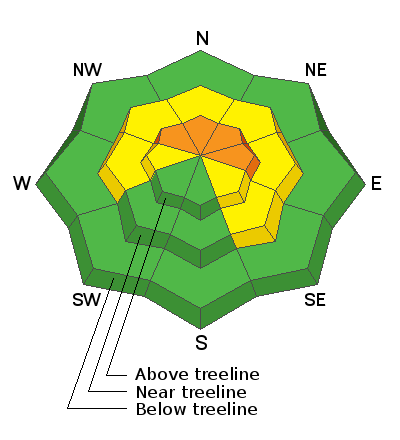
Areas of CONSIDERABLE danger exist on steep, wind drifted, northwest through east-facing slopes above treeline. As new snow accumulates, we could see some natural soft slab releases or fast running, loose snow sluffs off of some of the larger and steeper terrain so give it a wide berth. There also remains a MODERATE danger for triggering a deep and dangerous avalanche on a buried persistent weak layer of sugary, faceted snow on slopes near and above treeline that face northwest through southeast. Likely trigger points include thin snowpack areas along slope margins or around rock outcroppings. Wind drifted snow will add additional stress to these areas. Most south, southwest, and low elevation terrain offers generally LOW danger.
Low
Moderate
Considerable
High
Extreme
Learn how to read the forecast here
Special Announcements
Weather and Snow
The much advertised low-pressure system is currently moving through Southern Utah with a strong southerly flow advecting a steady stream of moisture over our region. Today should see periods of heavy snowfall before the flow shifts to a less favorable westerly this afternoon. 3"-5" are possible today. Tonight should see another uptick in precipitation as wraparound moisture shifts the flow to the northwest and we could see another 2"-4" by Sunday morning. Most of the action will be over on Sunday with lingering showers and blustery NW winds. A short-lived, low amplitude ridge builds on Monday before the next low-pressure system moves through the region on Tuesday, followed by ridge building, and drier and warmer conditions through the end of the week.
Snow totals at Buckboard Flat (8924')
Snow totals at Camp Jackson (8858')
Snowpack Discussion
In our travels up above North Creek Pass on Thursday, we found that the fresh snow had improved conditions though crusts and old tracks could still be felt underneath, particularly on sunnier aspects. The new, low-density snow will be easily transported today by the wind and fresh, unstable drifts will be found on the leeward sides of ridge crests and terrain features, primarily in upper elevation, wind exposed terrain. As winds increase today, we could see some natural soft slab releases or fast running, loose snow sluffs off of some of the larger and steeper terrain. Today is a good day to stay out from underneath long-running slide paths. If you are headed up North Creek, travel under paths that threaten the road one at a time, and don't dawdle. Persistent weak layers of faceted snow still exist in the lower portion of the snowpack, and stability tests indicate that it is still possible to trigger an avalanche on a buried weak layer. Steep, northerly-facing terrain remains the most likely area to trigger this kind of avalanche.
Additional Information
Information on outdoor recreation - The State of Utah created this webpage with information about recreating on both state and federal public lands during the current health crisis.

New to the backcountry (including riding at closed resorts) - Watch the award-winning, 15 minute Know Before You Go video, or take the 5-part, free online-learning series.
General Announcements
This forecast is from the U.S. Forest Service, which is solely responsible for its content. This forecast describes general avalanche conditions and local variations always occur.