Forecast for the Abajos Area Mountains

Eric Trenbeath
Issued by Eric Trenbeath on
Wednesday morning, December 4, 2019
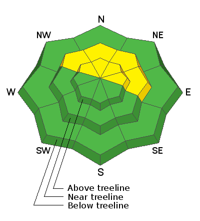
Today there is an isolated or MODERATE danger for human triggered avalanches on a buried persistent weak layer on steep slopes facing NW-N-E. There also remains an isolated possibility of triggering an old, hard wind slab on steep, upper elevation, northerly facing terrain. Most other terrain offers LOW danger. Expect an increasing danger by tomorrow with an approaching storm.
Low
Moderate
Considerable
High
Extreme
Learn how to read the forecast here
Special Announcements
The First Annual Avalanche Awareness Week is December 2-7 We have a week full of fun and educational events planned. Check out the schedule here.
The annual free Know Before You Go avalanche awareness talk will be held at the Grand County Library on Thursday, Dec 5 at 6:00 p.m. Hope to see you there!
Weather and Snow
Clouds will build today as the next storm system approaches our area. We'll see a chance of showers later today with SW winds averaging 15-20 mph along ridge tops. high temps at 10,000' will be around 30 degrees. The real action starts late tonight and we should get a good shot of snow out of this. It looks like 6"-10" with maybe up to a foot possible.
It was a wild Thanksgiving week in the Abajos with lots of snow and wind. A storm on Tuesday and a two-part storm over Thanksgiving brought 3'-4' to the mountains and coverage is the best I have seen for this time of year. Strong winds from all directions have taken a bit of a toll leaving some exposed slopes blasted down to the grass while leaving others remarkably intact. Soft, settled powder can still be found however in many locations.
Snowpack Discussion
In our travels Sunday we saw evidence of cracking and slab failure that had occurred during the storm but we saw no actual avalanches, and instabilities within the storm snow had settled out. We noted the presence of wind drifts on steep slopes that should still be avoided, but overall we found a mostly strong snowpack devoid of reactive weak layers. At 10.000' we measured 62" of snow. Travis Nauman, on the other hand, sent in this observation where he noted the presence of reactive weak layers on NE aspect around 9000' which is certainly a cause for concern. We currently have very limited data and until we gather more, a slope by slope analysis will need to conducted before venturing on to steep, northerly facing terrain.
Snow totals at Buckboard Flat (8924')
Snow totals at Camp Jackson (8858')
Wind, temperature, and humidity on Abajo Peak (11,000')
General Announcements
This forecast is from the U.S. Forest Service, which is solely responsible for its content. This forecast describes general avalanche conditions and local variations always occur.