Forecast for the Abajos Area Mountains

Eric Trenbeath
Issued by Eric Trenbeath on
Saturday morning, December 14, 2019
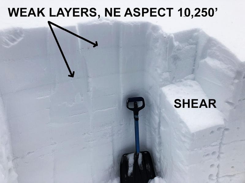
Look for a rise in avalanche danger over the next 24 hours. Blowing and drifting snow will cause the avalanche danger to rise to MODERATE today on steep upper elevation terrain that faces NW-N-E. Look for fresh drifts to form on the lee sides of ridge crests and terrain features such as sub-ridges or gully walls. Be alert to signs of instability such as cracking in the snow surface. New snow amounts and wind will dictate the rise in danger. And as additional weight is added to the snowpack, it may also be possible to trigger an avalanche on a buried persistent weak layer on steep, upper elevation, northerly facing terrain.
Low
Moderate
Considerable
High
Extreme
Learn how to read the forecast here
Special Announcements
The first UAC podcast of the season " Early Season Essentials with Program Director Bo Torrey" check it out HERE.
Get one of these cool t-shirts to support the UAC and other avalanche centers across the U.S.
Weather and Snow
Trace amounts of snow have fallen overnight. WSW winds overnight blew 20-30 mph with gusts into the 40's before backing off and swinging around to the WNW early this morning. They are currently light and westerly. 10,000' temps are in the mid 20's. A band of mid-level clouds is currently spreading over the area as the next wave of energy spills down from the north. Today look for increasing clouds and westerly winds with snowfall beginning later today - likely this afternoon or evening and continuing overnight. 3"-6" seem likely.
Snow depths range from 30" at Camp Jackson and Buckboard Flat (9000') to more than 4' of snow at North creek Pass (10,500'). Some sun and wind-exposed slopes have considerably less and there is still some grass poking out, but all said we're off to a good start down here.
Snow totals at Buckboard Flat (8924')
Snow totals at Camp Jackson (8858')
Wind, temperature, and humidity on Abajo Peak (11,000')
Avalanche Problem #1
Wind Drifted Snow
Type
Location
Likelihood
Size
Description
Blowing and drifting snow today may create unstable wind slabs sensitive to the weight of a skier or rider in upper elevation, wind-exposed terrain on slopes facing primarily NW-N-E. Look for fresh drifts forming on the leeward sides of ridge crests and terrain features including sub-ridges and gully walls. Wind drifts are recognizable by their smooth, rounded appearance, and cracking in the snow is a sign of instability. These fresh drifts will be mostly shallow and manageable today, but a greater concern is that they will add additional stress to a buried, persistent weak layer causing a deeper, and potentially more dangerous avalanche.
Avalanche Problem #2
Persistent Weak Layer
Type
Location
Likelihood
Size
Description
Generally speaking, the mountains have a deep, strong snowpack for this time of year without the typical layer of weak, sugary "faceted" snow at the base. In my travels on Friday, 13 however, I observed two weak layers that have formed in the upper 12"-18" of the snowpack. Though not overly reactive at this time, there is a possibility for triggering an avalanche on one of these buried weak layers on steep slopes facing NW-N-E, especially in areas that have overlying deposits of wind drifted snow. We will want to pay attention to these weak layers as new or wind drifted snow will add additional stress, increasing the likelihood of triggering an avalanche.
General Announcements
This forecast is from the U.S. Forest Service, which is solely responsible for its content. This forecast describes general avalanche conditions and local variations always occur.