Forecast for the Abajos Area Mountains

Eric Trenbeath
Issued by Eric Trenbeath on
Sunday morning, December 1, 2019
Unstable areas of wind drifted snow still exist and the avalanche danger remains CONSIDERABLE on steep, wind drifted slopes, right around treeline and above that face NW-N-E. There also remains a MODERATE danger for triggering an avalanche in the most recent storm snow on steep slopes of all aspects at mid and upper elevations. Low elevation south-facing terrain has mostly LOW danger.
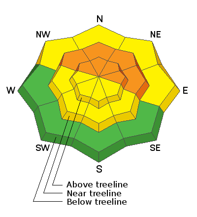
Low
Moderate
Considerable
High
Extreme
Learn how to read the forecast here
Special Announcements
The First Annual Avalanche Awareness Week is December 2-7 We have a week full of fun and educational events planned. Check out the schedule here.
The annual free Know Before You Go avalanche awareness talk will be held at the Grand County Library on Thursday, Dec 5 at 6:00 p.m. Hope to see you there!
Weather and Snow
I do not have a lot of on the ground information from the Abajos. I do know that 3'-4' of new snow has fallen since Wednesday night. Winds throughout the storm event have blown in the 30-35 mph range with gusts into the 50's, first from the SE, then shifting to SW before coming around to the NW. In short, it's been a lot of snow with a lot of wind which translates to avalanche problems. Time helps to stabilize the snowpack, and I'm sure we are trending toward more stable conditions but for now I'm going to have to assume we still have some problems. I'll get down there today and have a look around.
It's going to be a beautiful day in the mountains with high temps in the upper 20's and light NW winds. We'll see dry conditions through Tuesday with our next chance for snow coming on Wednesday.
Snow totals at Buckboard Flat (8924')
Snow totals at Camp Jackson (8858')
Wind, temperature, and humidity on Abajo Peak (11,000')
National Weather Service point forecast.