Forecast for the Abajos Area Mountains

Eric Trenbeath
Issued by Eric Trenbeath on
Saturday morning, November 30, 2019
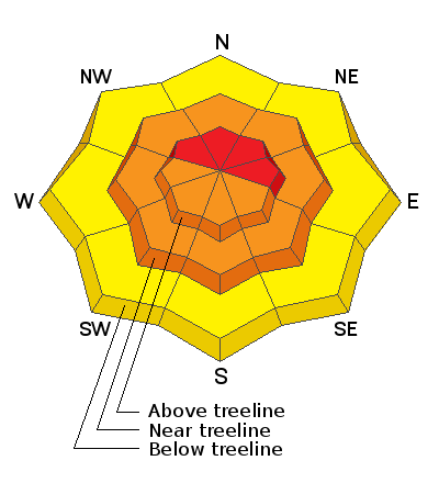
Heavy snowfall accompanied by strong winds have created dangerous avalanche conditions! The avalanche danger is HIGH today on steep, upper elevation, wind drifted slopes that face primarily NW-N-E. The avalanche danger is CONSIDERABLE on steep slopes on all aspects at mid and upper elevations where human triggered avalanches involving the most recent storm snow are likely. Backcountry travelers need to possess excellent route finding skills. Travel in avalanche terrain is not recommended. Backcountry travelers need to have good route finding skills and know how to avoid being on or underneath avalanche terrain. Avoid steep wind drifted slopes and stay out from under run out zones and drainage bottoms.
Low
Moderate
Considerable
High
Extreme
Learn how to read the forecast here
Special Announcements
The First Annual Avalanche Awareness Week is December 2-7 We have a week full of fun and educational events planned. Check out the schedule here.
The annual free Know Before You Go avalanche awareness talk will be held at the Grand County Library on Thursday, Dec 5 at 6:00 p.m. Hope to see you there!
Weather and Snow
More than 3' of new snow has fallen in the Abajo Mountains since Wednesday night. Winds throughout the storm event have blown in the 30-35 mph range with gusts into the 50's, first from the SE, then shifting to SW before coming around to the NW. They'll back off a little today but will still average 20-25 mph with gusts to 30 along ridge tops. Skies will clear today and it's going to be cold. High temps at 10,000' will be in the mid-teens with a wind chill factor of -15. Sunday will be sunny and warmer with dry conditions through Monday.
Snow totals at Buckboard Flat (8924')
Snow totals at Camp Jackson (8858')
Wind, temperature, and humidity on Abajo Peak (11,000')
National Weather Service point forecast.