Forecast for the Abajos Area Mountains

Eric Trenbeath
Issued by Eric Trenbeath on
Monday morning, January 25, 2021
New and wind drifted snow has added stress to underlying persistent weak layers creating dangerous avalanche conditions in the Abajo Mountains. The avalanche danger is HIGH on steep, upper elevation slopes facing NW-N-E. At mid and lower elevations the avalanche danger is CONSIDERABLE. South-facing terrain has a MODERATE avalanche danger. Conditions are deceiving due to the lack of overall snow this year but they are dangerous. Avoid steep, north-facing slopes and connected lower angle terrain.
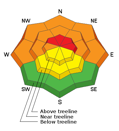
Low
Moderate
Considerable
High
Extreme
Learn how to read the forecast here
Special Announcements
Do you have the essential avalanche rescue gear (transceiver, probe, and shovel) and do you know how to use them? Watch this video to see how the three pieces of equipment work together.
Weather and Snow
Slow and steady, the snow is beginning to stack up with another 7" at Buckboard Snotel overnight. Overnight WNW winds were mostly light before shifting back to the SW where they should remain mostly light today. Look for lingering showers this morning and mostly cloudy skies before the next system moves into the area this evening. This storm seems to be taking a slightly more southerly track but I thought that before. Right now it looks like we'll see about 3"-5". Brief ridging will occur on Wednesday before moving on Thursday, followed by the next Pacific low that will start moving into the region on Friday.
Snow totals at Buckboard Flat (8924')
Snow totals at Camp Jackson (8858')
Snowpack Discussion
I found very sensitive conditions in my travels on Saturday as new and wind drifted snow had formed a dense, cohesive slab on top of the weak, sugary, faceted snow underneath. Red flag signs of instability such as shooting cracks and collapsing were rampant. Things are deceiving out there, at first glance it doesn't appear that there is enough snow for avalanches. But on steep, northerly aspects where there is enough snow, conditions are ripe. Steep, north through east facing terrain should be avoided for the foreseeable future.
The video below illustrates the red flag signs of instability I observed.
Additional Information
Information on outdoor recreation - The State of Utah created this webpage with information about recreating on both state and federal public lands during the current health crisis.

New to the backcountry (including riding at closed resorts) - Watch the award-winning, 15 minute Know Before You Go video, or take the 5-part, free online-learning series.
General Announcements
This forecast is from the U.S. Forest Service, which is solely responsible for its content. This forecast describes general avalanche conditions and local variations always occur.