Forecast for the Ogden Area Mountains

Nikki Champion
Issued by Nikki Champion on
Wednesday morning, February 19, 2025
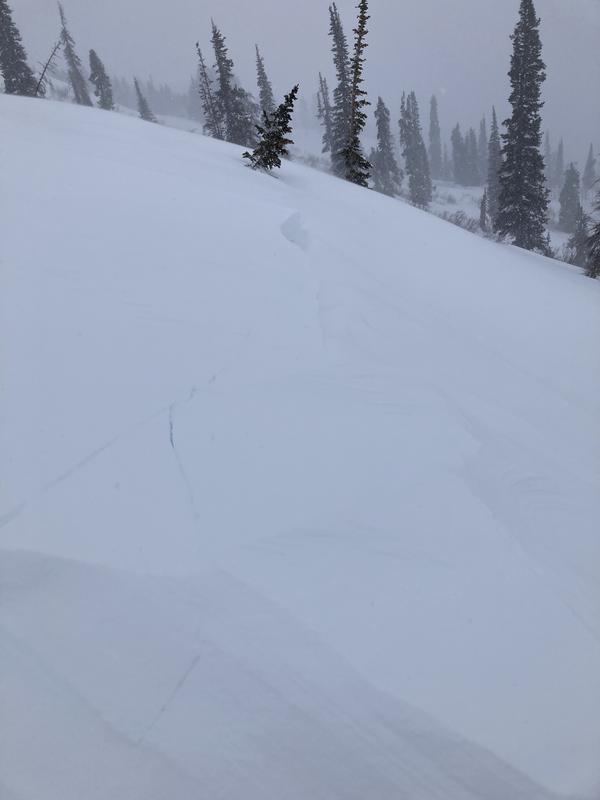
Avalanche danger remains CONSIDERABLE on upper-elevation slopes and mid-elevation slopes facing northwest through north to east, where triggering an avalanche on one of several buried weak layers is likely. This danger extends to many other steep slopes due to wind-drifted and lingering new snow. MODERATE danger exists on lower-elevation slopes and mid-elevation slopes facing west through south to southeast, where human-triggered avalanches are still possible.
While danger has decreased, the travel advice remains the same—avoid avalanche terrain. If you do travel in avalanche terrain, take all necessary precautions: cross or ride one at a time, watch from a safe spot, and have and know how to use avalanche rescue gear.
Low
Moderate
Considerable
High
Extreme
Learn how to read the forecast here
Special Announcements
Help the University of Utah understand risk behavior in the backcountry by participating in a 15-minute survey. The U will compensate up to $30 for your time! Please note: responses will not be confidential but will be handled ethically under IRB guidelines.
Weather and Snow
This morning, temperatures range from the mid-teens to upper 20s°F. Winds out of the west-southwest have been steady overnight, averaging 5–10 mph with gusts up to 20 mph at mid-elevations and 15–25 mph, gusting to 40 mph, on the highest ridgelines. Snowfall tapered off overnight, leaving a trace to 1 inch since yesterday morning.
Today, temps will rise into the mid-30s°F. A brief high-pressure system will settle over the area before giving way to partly cloudy skies and scattered snow showers this afternoon. Winds will stay westerly, averaging 5 mph with gusts up to 15 mph at mid-elevations and 15–30 mph, gusting to 35–40 mph, on the highest ridgelines. Expect a trace to an inch of new snow by sunset.
The main cold front will cross the northern Utah mountains late tonight through early Thursday, bringing the bulk of the storm’s snowfall. Snow will linger through Thursday, tapering off with 4–8 inches expected and up to 0.70 inches of water. High pressure will follow, bringing an extended stretch of dry weather.

Instability and natural avalanches are slowly decreasing, but we still don’t trust this snowpack. With the incoming storm, avalanche danger will rise again. Avalanches have been triggered on nearly every aspect and elevation in the past five days, and with multiple weak layers, it’s impossible to predict which one will fail. I don’t recommend navigating the hazard right now—plenty of excellent powder can be found on slopes under 30 degrees.
Recent Avalanches
One avalanche was reported Sunday from Rodeo Ridge. It was 14 inches deep, but due to the lighting, Bill Brandt couldn’t determine its width. It appears to have been a slab of wind-drifted snow. Greg was also on Rodeo Ridge that day, and ski resorts reported avalanche results from explosives.
Read all observations HERE.
Ad
Avalanche Problem #1
Wind Drifted Snow
Type
Location
Likelihood
Size
Description
Elevated winds continue to form sensitive wind drifts on all aspects at mid and upper elevations. Cornices have grown large and may break farther back from ridgelines than expected. Any avalanche involving wind-drifted snow could step down to a buried persistent weak layer.
Outside the wind-affected zones, especially on shaded slopes, new snow may still be reactive in steep terrain. These interfaces are slowly stabilizing, but soft slabs remain possible on many aspects and elevations.
Avalanche Problem #2
Persistent Weak Layer
Type
Location
Likelihood
Size
Description
This isn’t our typical February setup. We have four distinct weak layers buried in the snowpack that skiers and riders continue to trigger avalanches on.
Avalanches may fail on a variety of weak layers, on nearly any aspect, and it’s hard to determine which one. Now is not the time to thread the needle, hoping to find the one steep slope that won’t slide—there’s just too much spatial variability. Conditions can vary drastically over short distances, and snow pits may not reflect what’s happening nearby, even on similar aspects and elevations.
Additional Information
We've had four people tragically die already this year. Please do not try to outsmart the snowpack. Keep it simple and avoid steep terrain.
General Announcements
This information does not apply to developed ski areas or highways where avalanche control is normally done. This forecast is from the U.S.D.A. Forest Service, which is solely responsible for its content. This forecast describes general avalanche conditions and local variations always occur.