Forecast for the Ogden Area Mountains

Nikki Champion
Issued by Nikki Champion on
Thursday morning, February 20, 2025
Avalanche danger is CONSIDERABLE on all aspects and elevations.
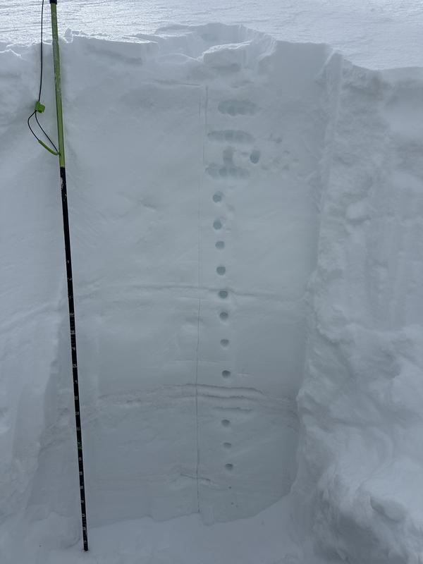
Periods of heavy snowfall and strong winds will create dangerous avalanche conditions. Expect avalanches within the storm snow and wind-drifted snow, with any slide potentially stepping down to one of the buried weak layers, triggering a deeper avalanche several feet deep and hundreds of feet wide. Stay alert—avalanche danger will rise as the storm intensifies. If the storm overproduces, avalanche danger could rise to HIGH by this evening, especially at upper elevations that receive the most snow and wind.
The travel advice remains unchanged—avoid avalanche terrain.
Low
Moderate
Considerable
High
Extreme
Learn how to read the forecast here
Special Announcements
Help the University of Utah understand risk behavior in the backcountry by participating in a 15-minute survey. The U will compensate up to $30 for your time! Please note: responses will not be confidential but will be handled ethically under IRB guidelines.
Weather and Snow
Heavy snowfall is blanketing the mountains this morning, with most areas in Ogden reporting 2-4 inches of snow and 0.30 inches of water as of 5 AM. Temperatures range from 20–30°F. Winds have been steady overnight from the west, with ridgetop gusts over 45 mph, but have since subsided to 10–15 mph, with gusts up to 30 mph.
The storm is arriving later than expected, with the heaviest snowfall between 7 AM and 2 PM, averaging 0.5 inches per hour. Snow density will decrease as colder air moves in, with an additional 3-6 inches expected by 5 PM.
Temperatures will remain in the mid-20s°F, and winds will shift to the northwest, averaging 10–15 mph with gusts up to 25 mph at mid-elevations and 15–25 mph, gusting to 35 mph, on the highest ridgelines. Storm totals are now estimated to be between 3–10 inches of snow, with up to 0.75 inches of water by tomorrow.

Avalanches have occurred on nearly every aspect and elevation over the past week, and multiple weak layers make the snowpack unpredictable. We don’t recommend traveling in avalanche terrain right now, but there’s good powder on slopes under 30 degrees.
Recent Avalanches
No avalanches were reported in the Ogden area backcountry yesterday. Ski resorts did report stubborn slabs or wind-drifted snow and storm snow yesterday.
Read all observations HERE.
Ad
Avalanche Problem #1
Wind Drifted Snow
Type
Location
Likelihood
Size
Description
Elevated winds continue to form sensitive wind drifts on all aspects at mid and upper elevations.
Watch for pillow-shaped deposits and avoid them. Signs of instability—shooting cracks, collapsing, and overhanging cornices—are clear indicators of wind-drifted snow and unstable terrain. Any avalanche in the new or wind-drifted snow has the potential to step down into one of the deeper persistent weak layers.
Avalanche Problem #2
Persistent Weak Layer
Type
Location
Likelihood
Size
Description
This isn’t our typical February setup. We have four distinct weak layers buried in the snowpack that skiers and riders continue to trigger avalanches on.
Avalanches may fail on a variety of weak layers, on nearly any aspect, and it’s hard to determine which one. Now is not the time to thread the needle, hoping to find the one steep slope that won’t slide—there’s just too much spatial variability. Conditions can vary drastically over short distances, and snow pits may not reflect what’s happening nearby, even on similar aspects and elevations.
Yesterday, on Cutler Ridge Richie Schumacher found the MF interface on a North Aspect at 8000'
Avalanche Problem #3
New Snow
Type
Location
Likelihood
Size
Description
Snowfall is increasing, and so is avalanche danger. Up to 8" of new snow could lead to fast-running sluffs, especially at upper elevations.
Sensitivity depends on snowfall rates—anything over 2” per hour makes avalanches more likely. Watch for cracking and sluffing, as even small slides can be dangerous in steep terrain.
Additional Information
Four people have already lost their lives this season—a tragic reminder of how unforgiving this snowpack is. Don’t try to outsmart it. Keep it simple: avoid steep terrain and stick to safer, lower-angle slopes.
General Announcements
This information does not apply to developed ski areas or highways where avalanche control is normally done. This forecast is from the U.S.D.A. Forest Service, which is solely responsible for its content. This forecast describes general avalanche conditions and local variations always occur.