AVALANCHE WARNING!! Tap for info
UDOT PLANNED AVALANCHE CLOSURES!!

Forecast for the Provo Area Mountains

Trent Meisenheimer
Issued by Trent Meisenheimer on
Saturday morning, January 18, 2025
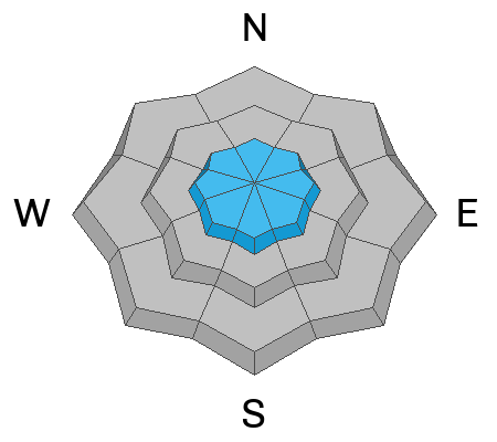
The avalanche danger is MODERATE on all upper elevation aspects where there are fresh, shallow soft slabs of wind-drifted snow.
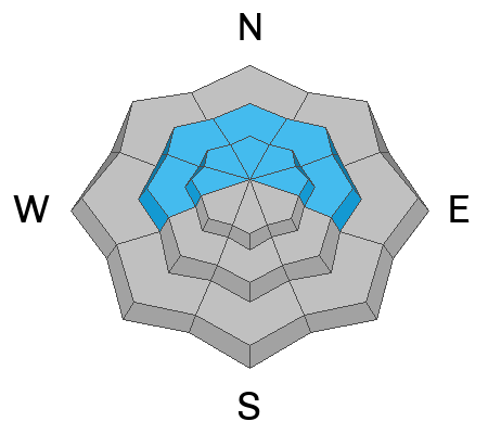
The avalanche danger is MODERATE on upper elevation aspects facing northwest through north and east where it is possible to trigger an avalanche failing in a persistent weak layer buried 2-3 feet deep.
Low
Moderate
Considerable
High
Extreme
Learn how to read the forecast here
Special Announcements
Join the UAC at Deer Valley on January 30th for the 2nd Annual Blizzard Ball Gala. The night will be full of fun including delicious cuisine, live music, an auction, and presentation by Bruce Tremper.
Weather and Snow
This morning, it's trying to snow. Overnight totals are zero to 5 inches of new snow with 0.00 to 0.11 inches of snow water equivalent. Tibble Fork in American Fork is the only station reporting any measurable precipitation. It seems everything south of there is dry and there is no new snow. The northwest wind continues to blow at speeds of 5-15 mph with gusts into the 20s. Let's not forget about the mountain temperatures; they're cold! temperatures range from 5 to 15 °F with wind chills ranging from -5 to -18 °F. Brrrrr.

Unfortunately, this storm is not going to favor the Provo area. Throughout the day, we could see light snowfall, which might add up to 1 to 3 inches of new snow if we are lucky. The northwest wind will stay elevated throughout the day, with speeds of 5-15 mph, gusting into the 20s.
Recent Avalanches
No new human-triggered avalanches were reported yesterday.
Ad
Avalanche Problem #1
Wind Drifted Snow
Type
Location
Likelihood
Size
Description
Yesterday, the northwest wind picked up around 10:00 am, averaging 15-25 mph with gusts into the 20s and 30s throughout the day and night. This morning the wind is still elevated and will remain elevated throughout the day. Because of this, I would expect shallow sensitive drifts of wind-blown snow across all upper-elevation terrain. These avalanches will be soft slabs of wind-drifted snow that could be extra sensitive because they either formed over a slick sun crust (sunny side) or our weak and faceted snow surface (shady side).
Avalanche Problem #2
Persistent Weak Layer
Type
Location
Likelihood
Size
Description
A buried layer of faceted snow and depth hoar 2-4 feet deep exists at the mid and upper elevations on aspects facing northwest through east. The last reported avalanche failing on this layer was on January 5 on the Ant Knolls. But to our north, where there is a similar snowpack structure, avalanches failing on the PWL are reported almost daily. I would advise caution and continue to avoid steep terrain on the north side of the compass.
General Announcements
This information does not apply to developed ski areas or highways where avalanche control is normally done. This forecast is from the U.S.D.A. Forest Service, which is solely responsible for its content. This forecast describes general avalanche conditions and local variations always occur.