Forecast for the Uintas Area Mountains

Craig Gordon
Issued by Craig Gordon on
Wednesday morning, December 18, 2024
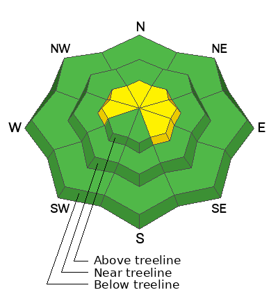
In the wind zone at and above treeline you'll find MODERATE avalanche danger today. While not widespread, human triggered avalanches breaking several feet deep are still POSSIBLE, especially on steep, wind drifted slopes facing the north half fo the compass.
Lose some elevation, you lose the wind, you lose the problem and you'll find generally LOW avalanche danger around the dial in mid and lower elevation terrain.
Inside line- as the hazard decreases and confidence increases, I'm motivated to start stepping into bigger terrain. But... before blindly jumping onto steep slopes, I play a little mini golf and gather some snowpack stability intel by stomping on small test slopes similar to what I wanna ride and see how they're reacting to my additional weight. This approach gives me a little wiggle room on my options and opens the door to a variety of less enthusiastic objectives if I don't like what I'm seeing.
Low
Moderate
Considerable
High
Extreme
Learn how to read the forecast here
Weather and Snow
Nowcast-
Yesterday's storm yielded just a couple inches of snow and a shallow coat of white paint, but now slides to the east, opening the door to clear skies and temperatures registering in the teens and mid 20's. Southwest winds took a short break from their busy schedule, (you know... kids, soccer practice, Christmas shopping :) but are getting after it early this morning, blowing 20-30 mph near the high peaks. It's a mixed bag out there and it's been a slow start to winter with settled snow depths averaging just about 2' across the range. Riding and turning conditions are acceptable, but tread lightly, there's no shortage of buried treasures lurking just below the snow surface.
Forecast-
Storminess slides to the north and I think we'll see a band of clouds drift through the Uinta's later morning before high pressure takes hold, delivering mild temperatures climbing into the low 30's. Overnight lows dip into the teens. Winds blowing in the 30's from the southwest are gonna be a nuisance along the high ridgelines this morning, but decrease as the day wares on.
Futurecast-
Not much going on in the weather department. Look for clear skies, warming temperatures, and reasonable winds... rinse and repeat through the weekend. But wait... there's more! Computer models agree with a more active pattern developing between Christmas and the New Year. We'll keep ya posted on this developing story.
Recent Avalanches
No avalanche activity since Sunday, December 15th near Hoyt Peak where Micheal J remotely triggered a fresh wind drift from a distance.
Read more from Michael's ob here and from across the range, here -- Thanks to MJ for the great photos!
Ad
Avalanche Problem #1
Wind Drifted Snow
Type
Location
Likelihood
Size
Description
Recent winds have blown from nearly every direction and jerked our shallow snowpack all over the place, delivering uneven drifting patterns and a patchwork of slabs. And although not quite as reactive as the past few days, I suspect if you were looking to trigger an avalanche you could find a pocket or two in the alpine. And remember... today's avalanches may break deeper and wider than you might expect and could easily knock you off your feet and take you for a body bruising ride through rocks, stumps, or deadfall.
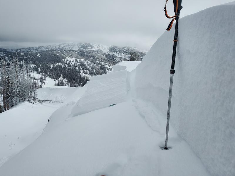
Be on the lookout for red flags like cracking in the image above (thanks Weston D) and steer clear of fat, rounded pillows of snow. Consider avoiding drifted areas in the wind zone today and seek out wind sheltered terrain where coverage and riding are a bit more reasonable and the avy hazard is generally low. ... done, done, and done :)
Avalanche Problem #2
Persistent Weak Layer
Type
Location
Likelihood
Size
Description
The snowpack didn't get walloped by the recent round of storminess, but it's got a variety of weak layers and I don't necessarily trust it. The good news... there's plenty of low angle slopes out there where we can ride safely today and not trigger a slide. The bad news... while more the exception than the rule, once initiated, today's avalanches may break to fragile layers of snow now buried a couple feet deep, delivering a slide that's bigger than you might've bargained for.
General Announcements
Additional Information
The Uinta weather station network was upgraded this summer and all that real-time info is found here. Simply click on the "Western Uinta" tab and then the "Weather Stations" tab to find all your weather needs.
We are always looking for snow and avalanche observations or just general riding conditions. So... if you see something, say something. You can reach our team directly by contacting: Craig at craig@utahavalanchecenter.org, 801-231-2170, or Andrew at andy@utahavalanchecenter.org, or 860-460-8142.
General Information
This forecast is from the U.S.D.A. Forest Service, which is solely responsible for its content. This forecast describes general avalanche conditions and local variations always occur. This forecast was issued on Wednesday, December 18th at 03:30 AM and expires 24 hours after it was issued. We will update the forecast by 0700 AM tomorrow. But, in the meantime reach out to us with questions, or if you see anything in your travels.