Join us at our 2nd Annual Blizzard Ball

Forecast for the Moab Area Mountains

Eric Trenbeath
Issued by Eric Trenbeath on
Sunday morning, December 15, 2024
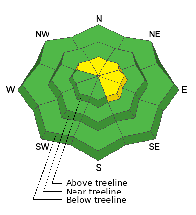
A MODERATE danger exists on steep slopes above treeline that face NW-N-E-SE for human triggered avalanches involving slabs of wind drifted snow. In these same areas, it may still be possible to trigger a deeper avalanche failing on a buried persistent weak layer. Choose terrain wisely. Avoid rocky, radical terrain, slopes with steep convexities, and areas with a thinner snowpack. Also avoid slopes with recent deposits of wind drifted snow.
Most other terrain has generally LOW danger. Small avalanches on isolated terrain features remain possible, particularly on slopes with a northerly aspect.
Conditions remain thin and rocks, stumps, and dead fall still pose a significant hazard.
Low
Moderate
Considerable
High
Extreme
Learn how to read the forecast here
Special Announcements
Only three spots remain for Moab and San Juan County locals for our Backcountry 101 class on Jan 31-Feb 1. Click here to sign up and use the discount code MOAB2025.
Geyser Pass Road: The road is plowed to the trailhead. Surface is dirt down low, snowpacked and icy above. AWD with good tires recommended.
The road above the trailhead officially closes to wheeled vehicles on Sunday, Dec 15. Grooming will commence shortly thereafter.
Weather and Snow
6 A.M. Snow and Weather Data
24 Hour Snow: 0" 72 Hour Snow: 0" Season Total Snow: 46" Depth at Gold Basin: 23"
Winds on Pre-Laurel Peak: SW 17 G 29 Temp: 22° F Percent of Normal (SWE): 135%
Weather
SW winds continue to crank over the ridge tops gusting to 40 mph for a few hours around midnight. They'll back off and shift to more westerly today as the trough axis moves on into Colorado. Today look for sunny skies, light to moderate westerly winds, and high temps in the mid 20's. Long range models are beginning to show some snow right around Christmas.
General Conditions
Conditions are officially a mixed bag and with overall thin cover, it's getting harder to find good turns. Ridgetop winds continue to erode snow from south and westerly aspects while depositing snow on to leeward, north and easterly facing slopes. I've received a few reports of isolated wind slabs cracking out in the high country including this one from Aaron Kawcak. The sun has also greatly affected solar aspects and many are bare or crusted over.
Structure remains poor with a weak, faceted layer beneath a slab, but stability tests have been generally non-reactive. Nevertheless, this classic combination of dense slab, over weaker, faceted snow, is very difficult for avalanche forecasters to trust. So how do we handle it? We either continue to avoid avalanche terrain altogether, or we dip our toes into it. We definitely avoid areas of steep, rocky, radical, and wind affected terrain. We don't just center punch the biggest lines. We choose moderately steep, planar slopes less than 35 degrees, and we avoid likely trigger points such as steep convexities, or shallow points along slope margins and near rock outcrops. We remind ourselves that it's early season, that avalanches are still possible, and we proceed with great caution.
Snowpack and Weather Data
Gold Basin SNOTEL site (10,000')
SNOTEL site near Geyser Pass Winter Trailhead (9600')
Wind Station on Pre-Laurel Peak (11,400')
NWS forecast for the La Sal Mountains.
Recent Avalanches
No recent avalanches have been reported. See the avalanche database here.
Ad
Avalanche Problem #1
Wind Drifted Snow
Type
Location
Likelihood
Size
Description
Recently formed, unstable slabs of wind drifted can be found above treeline on slopes facing NW-N-E-SE. Wind slabs are recognizable by their smooth rounded appearance, and they may sound or feel hollow underneath. Cracking is a sign of instability. Wind slabs exist in the same areas where the persistent weak layer problem remains a concern. Generally speaking, continuing to avoid this type of terrain is the safest strategy.
Avalanche Problem #2
Persistent Weak Layer
Type
Location
Likelihood
Size
Description
It's becoming less likely to trigger an avalanche with each passing day but poor snowpack structure, comprised of a dense slab over weak, faceted snow remains. The faceted weak layer is showing signs of gaining strength, meaning that it's becoming more dense, and stability tests performed near treeline and below are generally non-reactive. This, plus the time that has expired since the last loading event and subsequent avalanche cycle, indicate growing stability. Nevertheless, it's still possible to trigger an avalanche if you find the sweet spot, particularly in steep, rocky, wind affected terrain above treeline that faces NW-N-E.
Looking ahead, the snow surface continues to weaken and this will undoubtedly become a future weak layer when new snow finally comes. The underlying structure will also likely become re-active again.
Additional Information
Sign up for text alerts to get the most up to date information about changing conditions, road plowing, special avalanche announcements.
Follow us on Instagram @utavy_moab
General Announcements
This forecast is from the U.S.D.A. Forest Service, which is solely responsible for its content. This forecast describes general avalanche conditions and local variations always occur.