Forecast for the Skyline Area Mountains

Brett Kobernik
Issued by Brett Kobernik on
Friday morning, December 13, 2024
The avalanche danger on the Manti Skyline is rated MODERATE.
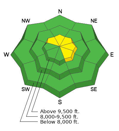
Your main concern today is the chance of triggering a pocket of wind drifted snow.
The most likely place to trigger one of these pockets is upper elevation very steep slopes right near the ridgelines, especially on east and northeast aspects.
In areas where the wind has not drifted snow, the avalanche danger is generally LOW.
Low
Moderate
Considerable
High
Extreme
Learn how to read the forecast here
Weather and Snow
Current Conditions: Riding conditions remain fairly decent and should be even better with a little fresh snow today. Wind from the southwest has increased a bit overnight. Daytime high temperatures have been in the low 30s. Temperatures are in the teens this morning.
Mountain Weather: It's currently snowing as of 6am. A small storm will move through this morning leaving us with possibly a few inches of snow. Wind from the west will be a bit breezy this morning and then gradually slow through the day. High temperatures will be in the low to mid 20s. Another system moves through Saturday into Sunday but it looks like most of the precipitation stays north of our area. I'm only expecting a few inches of snow from this event.
Ad
Avalanche Problem #1
Wind Drifted Snow
Type
Location
Likelihood
Size
Description
Human triggered avalanches are possible in the higher terrain where the wind has formed fresh drifts and slabs.
Areas where these drifts and slabs formed on top of loose sugary faceted snow are the most dangerous. This is in the higher terrain on northwest through east facing slopes with northeast and east aspects the most suspect.
These avalanches will be relatively small but don't let your guard down. If you keep an eye out for these fresh drifts and avoid them, you won't have to worry about avalanches today.
General Announcements
This forecast is from the U.S.D.A. Forest Service, which is solely responsible for its content. This forecast describes general avalanche conditions and local variations always occur.