Join us at our 2nd Annual Blizzard Ball

Forecast for the Skyline Area Mountains

Brett Kobernik
Issued by Brett Kobernik on
Saturday morning, December 14, 2024
The avalanche danger on the Manti Skyline is rated MODERATE.
Increased wind speeds this afternoon may increase the avalanche danger.
Human triggered avalanches are possible.
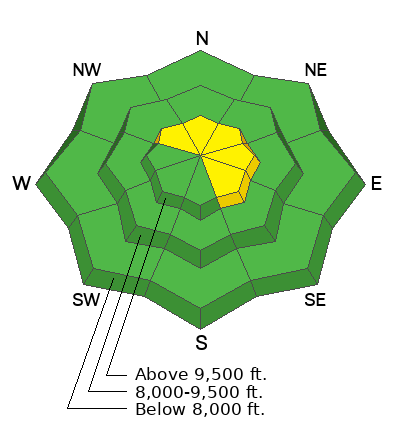
The most likely place to trigger one is on very steep upper elevation slopes that face east and north east right near the ridgelines where wind has deposited snow.
Low
Moderate
Considerable
High
Extreme
Learn how to read the forecast here
Weather and Snow
Current Conditions: Friday's small storm left 3 to 4 inches of new snow. There was some moderate speed wind during the storm so I'd expect to see some drifted snow, at least along the higher terrain. The wind has slowed for now. Temperatures are in the low to mid 20s.
Mountain Weather: Another storm is moving through but most of the precipitation is going to stay north of our region. It looks like it could get pretty windy today. Anticipate moderate to strong wind from the southwest as the day goes on. High temperatures will be around 30˚F. We'll see occasional periods of light snowfall possibly adding up to a few inches by Sunday. Longer term, it looks like there will be more small storms moving through but nothing huge at this point.
Ad
Avalanche Problem #1
Wind Drifted Snow
Type
Location
Likelihood
Size
Description
Wind drifted snow is your biggest concern today. The increase in wind speeds from the southwest will most likely form fresh drifts. These often are sensitive to people while they are forming and directly afterward. The most dangerous places will be where these form on top of weak, sugary, faceted snow.
Steep slopes right along the ridgelines that face northeast and east are the most suspect. That said, watch for drifts and pillows scattered about on all aspects in the higher terrain.
If you avoid drifts and pillows on steep slopes today, there is not much threat of avalanches.
General Announcements
This forecast is from the U.S.D.A. Forest Service, which is solely responsible for its content. This forecast describes general avalanche conditions and local variations always occur.