Forecast for the Moab Area Mountains

Dave Garcia
Issued by Dave Garcia on
Wednesday morning, December 11, 2024
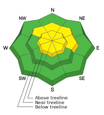
Above treeline, the avalanche danger is MODERATE for small soft slabs of wind-drifted snow. Elevated NW winds continue to blow and drift the small amount of new snow and weak pre-existing surface snow into sensitive cohesive slabs. Cracking beneath your skis is a sign of instability in freshly drifted snow.
MODERATE danger remains on slopes that face NW-N-E near treeline and above, where poor snowpack structure exists, and slabs can fail on a buried persistent weak layer. Human-triggered avalanches remain POSSIBLE.

Conditions remain thin and rocks, stumps, and dead fall still pose a significant hazard.
Low
Moderate
Considerable
High
Extreme
Learn how to read the forecast here
Special Announcements
Saturday, December 14 - 3rd Annual UAC Moab/LUNA Winter Kickoff Party, 6 PM at the MARC. Information and tickets available here.
Six spots remain for Moab and San Juan County locals for our Backcountry 101 class on Jan 31-Feb 1. Click here to sign up and use the discount code MOAB2025.
Geyser Pass Road: The La Sal Loop Road will be closed above Pack Creek Monday-Friday from 8:30 to 5:30 for construction through December 18. Access to the Geyser Pass Winter Trailhead will be from Castle Valley or Sand Flats Road during these hours. Click here for more information.
Weather and Snow
6 A.M. Snow and Weather Data
24 Hour Snow: 0" 72 Hour Snow: 2" Season Total Snow: 46" Depth at Gold Basin: 25"
Winds on Pre-Laurel Peak: NW 13-16 mph Temp: 13° F Percent of Normal (SWE): 164%
Weather
Under clear skies, temperatures in Gold Basin are 10 degrees warmer this morning than they were 24 hours ago. It is currently 13 degrees, and the high will reach 22 today. NW winds will back off and blow 5-10 MPH. Tomorrow will be similar to today, with increasing clouds in the afternoon. We may see some light snow flurries tomorrow night, but no accumulation is expected. Sunshine returns for Friday and Saturday with highs in the 20s.
General Conditions
Monday's weak storm system dropped 1-2 inches of low-density snow across the range with 0.1 - 0.2 inches of SWE. This is not enough snow to dramatically change the skiing and riding conditions, but any snow is welcome at this point. NW winds have been blowing hard since Monday night. Yesterday the winds blew in the 20s all day, with some gusts in the low 30's MPH. The snowpack has been losing strength during the long dry spell and the pre-existing snow surface consists of weak, loose, sugary faceted snow. Strong winds can easily blow and drift this weak surface snow. If you are traveling in the high country, look for freshly formed drifts on the lee-side of ridgelines and terrain features.
Strong winds and cold temperatures have diminished the quality skiing conditions we have been enjoying lately. Solar aspects will be frozen solid today. It will take some hunting around, but you can still find some soft turning on sheltered, shady slopes.
Snowpack and Weather Data
Gold Basin SNOTEL site (10,000')
SNOTEL site near Geyser Pass Winter Trailhead (9600')
Wind Station on Pre-Laurel Peak (11,400')
NWS forecast for the La Sal Mountains.
Recent Avalanches
It's been two weeks since the last avalanche cycle, but Chris Benson got around to Beaver Basin yesterday to have a closer look at a slide he reported earlier. It's quite impressive and worth a look.
See the avalanche database here.
Ad
Avalanche Problem #1
Wind Drifted Snow
Type
Location
Likelihood
Size
Description
NW winds have been elevated for the past 36 hours. Small, soft slabs continue to develop on the lee side of ridge crests and terrain features above treeline. These slabs will be shallow and small in size. Expect them to be sensitive and crack under the weight of your skis. While they might not be big enough to bury you, any avalanche will be a rough ride through rocks, given the shallow early season conditions. If you are traveling in the alpine, look out for and avoid fresh drifts. On some slopes, soft slabs may fail on pre-existing buried facets.
Avalanche Problem #2
Persistent Weak Layer
Type
Location
Likelihood
Size
Description
Out of the wind zone, it is becoming less likely to trigger an avalanche on the buried persistent weak layer with each passing day. The weak layer continues to adjust to the load, and it has been two weeks since the natural avalanche cycle that ran during the pre-Thanksgiving storm. However, poor snowpack structure remains. The overall snowpack has been getting weaker, but the slab hasn't completely deteriorated and still exists over the top of weak facets on many slopes. It is hard to trust this setup, especially with our shallow snowpack. The weight of a skier can more easily find a trigger point or "not-so-sweet" spot with a shallow snowpack. Trigger points include steep convexities, or shallow points along slope margins and near rock outcrops.
Additional Information
Sign up for text alerts to get the most up to date information about changing conditions, road plowing, special avalanche announcements.
Follow us on Instagram @utavy_moab
General Announcements
This forecast is from the U.S.D.A. Forest Service, which is solely responsible for its content. This forecast describes general avalanche conditions and local variations always occur.