Forecast for the Moab Area Mountains

Issued by Dave Garcia on
Tuesday morning, December 10, 2024
Tuesday morning, December 10, 2024
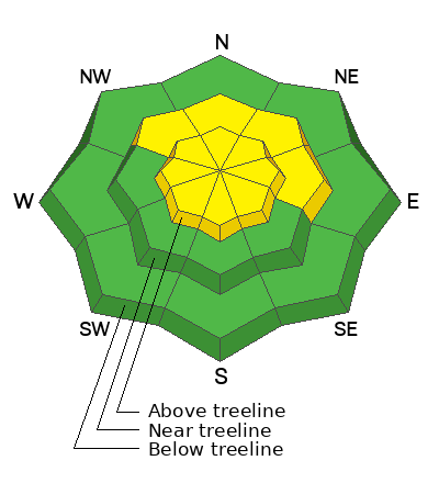
Above treeline, the avalanche danger is MODERATE for small soft slabs of wind-drifted snow. Elevated NW winds have blown and drifted the small amount of new snow and weak pre-existing surface snow into sensitive cohesive slabs. Cracking is a sign of instability in freshly drifted snow.
MODERATE danger remains on slopes that face NW-N-E near treeline and above, where poor snowpack structure exists, and slabs can fail on a buried persistent weak layer. Human-triggered avalanches remain POSSIBLE.
Conditions remain thin and rocks, stumps, and dead fall still pose a significant hazard.

Low
Moderate
Considerable
High
Extreme
Learn how to read the forecast here
 Special Announcements
Saturday, December 14 - 3rd Annual UAC Moab/LUNA Winter Kickoff Party, 6 PM at the MARC. Information and tickets available here.
Six spots remain for Moab and San Juan County locals for our Backcountry 101 class on Jan 31-Feb 1. Click here to sign up and use the discount code MOAB2025.
Geyser Pass Road: The La Sal Loop Road will be closed above Pack Creek Monday-Friday from 8:30 to 5:30 for construction through December 18. Access to the Geyser Pass Winter Trailhead will be from Castle Valley or Sand Flats Road during these hours. Click here for more information.
 Weather and Snow
6 A.M. Snow and Weather Data
24 Hour Snow: 2" 72 Hour Snow: 2" Season Total Snow: 46" Depth at Gold Basin: 25"
Winds on Pre-Laurel Peak: NW 12-15 mph Temp: 1° F Percent of Normal (SWE): 177%
Weather
Cold Northerly flow remains, and post-frontal temperatures are well below average. Skies are clear, and temperatures hover just above 0 degrees in Gold Basin this morning. We will reach 18 degrees for the high today. NW winds will continue to blow 15 MPH. For tomorrow, NW winds remain, but back off to 5-10 MPH, and clouds start to build. A small system affects the range on Thursday bringing light snow showers with little to no accumulation.
General Conditions
Yesterday's weak storm system dropped 1-2 inches of light snow across the range with 0.1 - 0.2 inches of SWE. This is not enough snow to dramatically change the skiing and riding conditions, but the big news is the wind. The last ten days have been remarkably calm in the mountains. Yesterday, NW winds blew in the teens all day and ramped up to the 20s last night with gusts in the low 30s MPH. The snowpack has been losing strength during the long dry spell and the pre-existing snow surface consists of weak, loose, sugary faceted snow. This weak snow is easily transported by strong NW winds. If you are traveling in the high country, be on the lookout for freshly formed drifts on the lee-side of ridgelines and terrain features.
Strong winds and plummeting temperatures will put a damper on the fun conditions we have been enjoying lately. Solar aspects will be frozen solid today. Expect to find a variety of wind-affected snow surfaces on the northerlies. Seek mid-elevation, sheltered slopes for the best turns today.
Snowpack and Weather Data
Gold Basin SNOTEL site (10,000')
Wind Station on Pre-Laurel Peak (11,400')
 Recent Avalanches
It's been nearly two weeks since the last avalanche cycle, but Chris Benson got around to Beaver Basin yesterday to have a closer look at a slide he reported earlier. It's quite impressive and worth a look.
Avalanche Problem #1
Wind Drifted Snow
Type
Location

Likelihood
Size
Description
An uptick in NW winds has created fresh slabs of wind-drifted snow above treeline. These slabs will be shallow, small in size, and found mostly on the lee-side of ridge crests. If you are getting up high, be on the lookout for and avoid fresh drifts. These fresh, soft slabs will be sensitive and crack under the weight of your skis. On some slopes, soft slabs may fail on pre-existing buried facets.
Avalanche Problem #2
Persistent Weak Layer
Type
Location

Likelihood
Size
Description
Out of the wind zone, it is becoming less likely to trigger an avalanche on the buried persistent weak layer with each passing day. The weak layer continues to adjust to the load, and it has been 13 days since the natural avalanche cycle that ran during the pre-Thanksgiving storm. However, poor snowpack structure remains. The overall snowpack has been getting weaker, but we still have a slab in place over weak facets on many slopes. I have a hard time trusting this setup, especially when you consider how shallow the overall snowpack is. The weight of a skier can more easily find a trigger point or "not-so-sweet" spot with a shallow snowpack. Trigger points include steep convexities, or shallow points along slope margins and near rock outcrops.
Additional Information
Sign up for text alerts to get the most up to date information about changing conditions, road plowing, special avalanche announcements.
Follow us on Instagram @utavy_moab
General Announcements
This forecast is from the U.S.D.A. Forest Service, which is solely responsible for its content. This forecast describes general avalanche conditions and local variations always occur.


