Forecast for the Provo Area Mountains

Issued by Nikki Champion on
Wednesday morning, November 27, 2024
Wednesday morning, November 27, 2024
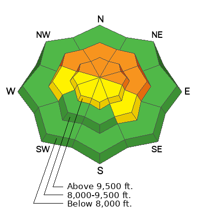
Avalanche danger is CONSIDERABLE danger on steep, wind-drifted westerly, northerly, and easterly aspects at upper elevations, as well as mid-elevation aspects facing northwest through east, which have received the highest snow totals and strongest winds.
Cracking and collapsing are critical signs of instability and should not be ignored today. Human-triggered avalanches 1–3 feet deep are likely, with some natural avalanches possible as winds remain elevated throughout the day. Outside the wind zone, the new snow may still be reactive, with small avalanches capable of moving fast and traveling farther than expected.
Remember, early-season conditions make injuries more likely if caught in an avalanche of any size.

Low
Moderate
Considerable
High
Extreme
Learn how to read the forecast here
 Special Announcements
The 17th Annual Utah Snow and Avalanche Workshop (USAW) is scheduled for Saturday December 7th - Information and tickets available here.
 Weather and Snow
This morning, light snow is falling in the mountains, and temperatures range from the low to mid-20s F. Winds have shifted from the south to the west-northwest, reaching gusts into the 20s mph at mid-elevations and nearly 50 mph at the uppermost elevations. Snowfall persisted overnight, adding another 1-2 inches as of 5 AM. The Provo area received some of the higher water totals, with heavy dense snow and rain falling below 5700'. Snow totals ended between 4-10" with 1.25-1.30" of water.
Today, moist northwest flow will keep unstable conditions and lingering snow showers in place early this morning, tapering off by afternoon as drier air moves in. Skies will begin to clear this afternoon, with gradual clearing continuing overnight. Temperatures will reach the mid to upper-20s F. Winds from the west-northwest will persist, remaining moderate with gusts reaching into the upper 30s mph at the higher elevations. There is a possibility of an additional trace amount of snow before this afternoon.
As for the weather outlook, it does not look good. You may need binoculars to see the next storm. And even that may not help.
 Recent Avalanches
No new avalanches reported from the Provo area.
You can find the most recent observations HERE.
Avalanche Problem #1
Persistent Weak Layer
Type
Location

Likelihood
Size
Description
While most the southerlies in Provo were dirt before this storm, anywhere that held snow was primed for avalanches: the classic strong-over-weak setup. It’s a tenuous balance, just waiting for enough new snow and wind to tip the scales. The key questions are whether the storm delivered enough of a load and if avalanches will be triggered today.
Given the water totals and sustained high winds, the answer is likely yes, but primarily in areas that receive the most snow and wind. Expect to trigger 1–3' deep soft slab avalanches on slopes facing west to east at mid and upper elevations. These slabs will likely fail within the old snowpack—a mix of weak, sugary facets and crusts. In steep, wind-drifted terrain, watch for shooting cracks, audible collapses, and the potential to trigger soft slabs.
Listen for whumphs or collapses, test small slopes to gauge reactivity, and look for shooting cracks. Extended Column Tests can also provide valuable information about snowpack stability. Proceed carefully and be prepared for reactive conditions.
Avalanche Problem #2
Wind Drifted Snow
Type
Location

Likelihood
Size
Description
Overnight westerly winds ramped up to nearly 60 mph. With strong winds and fresh snow available for transport, expect sensitive slabs of wind-drifted snow on upper-elevation slopes and mid-elevation terrain features prone to drifting. These slabs will be most pronounced on leeward (easterly) slopes, but high winds can load any aspect due to swirling and shifting directions, a phenomenon known as cross-loading.
Look for signs of wind-drifted snow, such as pillow-shaped deposits, and avoid those slopes.
The best riding conditions will be in sheltered, lower-angle terrain out of the wind.
Outside the wind zone, the new snow may still be reactive, with potential instabilities at the interface with the old snow surface or within storm or wind-blown layers. While these avalanches are likely to be small, they could move fast and travel farther than expected.
General Announcements
This information does not apply to developed ski areas or highways where avalanche control is normally done. This forecast is from the U.S.D.A. Forest Service, which is solely responsible for its content. This forecast describes general avalanche conditions and local variations always occur.


