Check out our Holiday Auction - Sign Up for the Utah Snow and Avalanche Workshop (USAW)

Forecast for the Provo Area Mountains

Nikki Champion
Issued by Nikki Champion on
Thursday morning, November 28, 2024
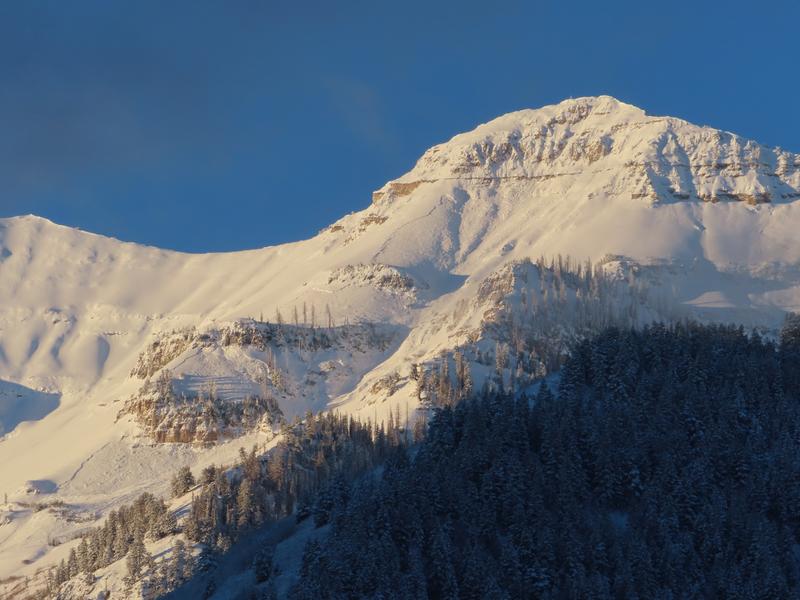
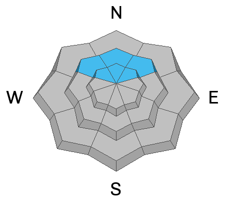
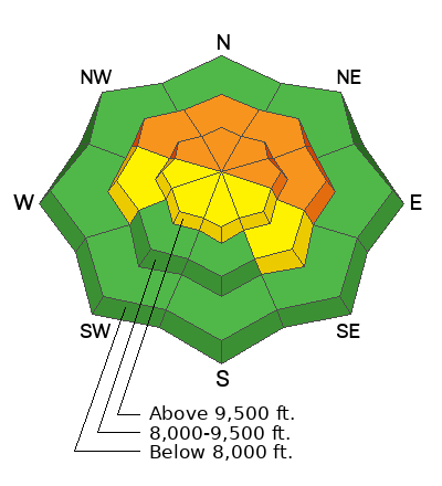
Avalanche danger is CONSIDERABLE on steep, northwesterly, northerly, and easterly aspects at mid and upper elevations. These areas have received the heaviest snow totals, the strongest winds, and harbor weak, faceted snow near the ground. Large natural avalanches were observed in the Provo area mountains during the peak of the storm.
Human-triggered avalanches, 1–3 feet deep, are likely today. These avalanches may release within the wind-drifted snow or step down to the persistent weak layer, resulting in much larger and more destructive slides. Watch for clear signs of instability, such as cracking and collapsing.
Even outside wind-affected zones, the new snow may remain reactive, with fast-moving, small avalanches capable of traveling farther than anticipated. Keep in mind, it’s still early season with a shallow snowpack. While a smaller avalanche may not fully bury you, it could easily sweep you through dangerous and unforgiving terrain.
Low
Moderate
Considerable
High
Extreme
Learn how to read the forecast here
Special Announcements
The 17th Annual Utah Snow and Avalanche Workshop (USAW) is scheduled for Saturday December 7th - Information and tickets available here.
Weather and Snow
This morning, skies are clear with temperatures in single digits to low teens. Winds remain westerly but have decreased since yesterday. Overnight, gusts reached 20 mph along the highest ridgelines, while most other elevations saw winds averaging 10-15 mph.
Snowfall wrapped up mid-day yesterday, bringing final storm totals to: 6-13" of snow (with 1.0-1.7" of water)
Today will be a gorgeous Thanksgiving day in the mountains. Northern Utah will remain on the cooler, dry side of a strengthening ridge over the Western Great Basin, with terrain-driven winds sticking around. Expect clear, sunny skies and gradually decreasing winds throughout the day. High temperatures will reach the mid to upper-20s °F. Northwest winds will persist, with gusts near 25 mph at higher elevations.
Looking ahead, the ridge will settle over the region Monday and remain through at least Wednesday or Thursday, keeping conditions dry and sunny. Temperatures will steadily warm, and inversions will strengthen, likely peaking midweek. There’s a slim 10-15% chance of a weak system grazing northern Utah late next week, but it doesn’t appear to bring much moisture. If it does, the main impact would be mixing out the inversions.
Recent Avalanches
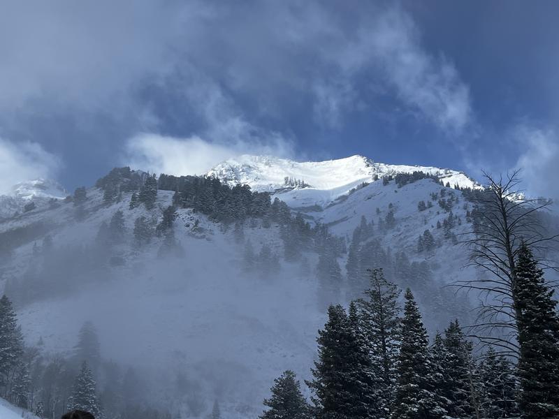
A natural avalanche cycle overnight during the storm in Big Springs/Cascade Ridge drainage. See photo below.
Ski areas reported recent avalanche activity, including natural activity up to D2 during periods of heavy snowfall. Long-running avalanches were triggered by control work on soft wind slabs, with collapsing and cracking observed in unskied terrain.
You can find the most recent observations HERE.
Ad
Avalanche Problem #1
Wind Drifted Snow
Type
Location
Likelihood
Size
Description
With multiple days of elevated winds and fresh snow available for transport, expect sensitive slabs of wind-drifted snow on upper-elevation slopes and mid-elevation terrain features prone to drifting. These slabs will be most pronounced on leeward (easterly) slopes, but high winds can load any aspect due to swirling and shifting directions, a phenomenon known as cross-loading.
Look for signs of wind-drifted snow, such as pillow-shaped deposits, and avoid those slopes. Any avalanche that fails within the wind-drifted snow on the northern end of the compass has the potential to step down and fail within the old snowpack—a mix of weak, sugary facets and crusts.
The best riding conditions will be in sheltered, lower-angle terrain out of the wind.
Outside the wind zone, the new snow may still be reactive, with potential instabilities at the interface with the old snow surface or within storm or wind-blown layers. While these avalanches are likely to be small, they could move fast and travel farther than expected.
Avalanche Problem #2
Persistent Weak Layer
Type
Location
Likelihood
Size
Description
The Provo area mounatins saw significant natural avalanche activity at the height of the storm.
While natural avalanches may have tapered off for now, the potential for triggering large, destructive avalanches remains high. Human-triggered avalanches are likely, and natural avalanche remain possible. Remember, a weak snowpack structure like this does not heal overnight.
Pay close attention to areas that received additional snow or wind-loading, particularly at upper elevations and wind-favored terrain. There’s a serious risk of triggering 1–3-foot-deep soft slab avalanches on west through east-facing slopes at mid and upper elevations. Any slide triggered in the wind-drifted snow could step down into the deeply buried, weak faceted layers, creating a much larger and more dangerous avalanche.
Stay alert to warning signs like whumphing sounds, collapses, and shooting cracks. Test small slopes to assess stability and use Extended Column Tests for critical insight into the snowpack’s reactivity.

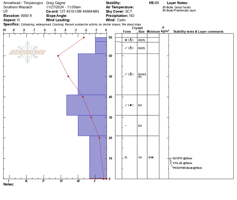
See Greg's snowpit profile from Arrowhead yesterday, you can see the obvious strong over weak structure that exists as well as another natural avalanche photo from Big Springs.
General Announcements
This information does not apply to developed ski areas or highways where avalanche control is normally done. This forecast is from the U.S.D.A. Forest Service, which is solely responsible for its content. This forecast describes general avalanche conditions and local variations always occur.