Forecast for the Salt Lake Area Mountains

Drew Hardesty
Issued by Drew Hardesty on
Monday morning, November 25, 2024
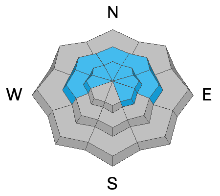
The avalanche danger is LOW and the snow is generally stable. Normal caution is advised.
IF the winds pick up earlier than expected and start blowing and drifting snow, the danger may rise to MODERATE by late afternoon.
***HEADS UP - With this next winter storm, we do expect dangerous avalanche conditions to develop over the next several days and well into Thanksgiving.***
Low
Moderate
Considerable
High
Extreme
Learn how to read the forecast here
Special Announcements
The 17th Annual Utah Snow and Avalanche Workshop (USAW) is scheduled for Saturday December 7th - Information and tickets available here.
Weather and Snow
As of 5AM, skies are clear and Orion the hunter looms large in the southwestern sky.
But a significant storm is on tap - the National Weather Service has issued a Winter Storm Warning for much of the mountainous terrain throughout the state for Monday night through Wednesday.
For today, we'll have increasing high and mid-level clouds by midday or early afternoon. Temperatures will rise into the upper 20s to low 30s. Keep an eye on winds increasing from the southwest this afternoon - they may start to blow into the 20-30mph range. By tonight, we will start to see the first precipitation from a large and complex storm system that should provide the mountains with 12-18" (1-1.75"SWE) of snow and more in favored locations. Initial rain/snow lines are expected to be 6500' or higher, but drop with frontal passage Tuesday evening. Snowfall should continue through Wednesday night. Unfortunately, it looks like we go into a period of high and dry for awhile afterwards.

Currently, temperatures are warming into the teens and winds are light from the south. It's still low-tide conditions for skiing and riding in the backcountry with 18-28" of snow on the ground, mostly just covering up the thinly buried rocks, stumps, and trees. Saturday night's 4-8" of new snow (up to 0.55" now water equivalent) was enough to entice a number of people into the mountains but not enough to help build our vertically challenged snowpack.
Recent Avalanches
Saturday night's storm mostly fizzled and did little to increase the avalanche danger in a significant way. Still, observers reported some loose dry sluffs in the steepest terrain and managed to trigger small pockets of wind slab in exposed terrain.
You can find the most recent observations HERE. Professional observers Will Ambler, Zack Little, Mark White, and UAC staff Joey Manship and Jeremy Collett and Mack Talty all contributed excellent reports.
Ad
Avalanche Problem #1
Persistent Weak Layer
Type
Location
Likelihood
Size
Description
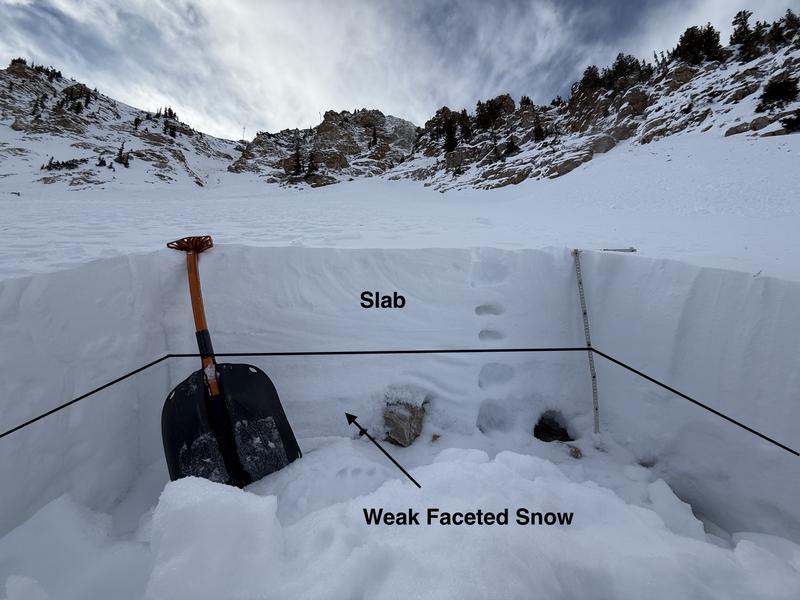
We have a weak and structured snowpack on the polar aspects (in general, west to north to east and possibly upper elevation southeast) that I fear will cause trouble with the upcoming storms. We've effectively built a house with a foundation of sugar. You can see Trent Meisenheimer's photo below from Friday. It's a poor set-up.
Photo: Upper Little Cottonwood Canyon showing the snowpack structure on a north-facing slope at 10,200'.

All we need is a more significant load of snow and wind for these layers to collapse and avalanche. Dave Kelly and Nat Grainger's testing from Saturday (in an admittedly isolated area) hints at what is right around the corner.
General Announcements
This information does not apply to developed ski areas or highways where avalanche control is normally done. This forecast is from the U.S.D.A. Forest Service, which is solely responsible for its content. This forecast describes general avalanche conditions and local variations always occur.