Check out our Holiday Auction - Sign Up for the Utah Snow and Avalanche Workshop (USAW)

Forecast for the Moab Area Mountains

Eric Trenbeath
Issued by Eric Trenbeath on
Friday morning, December 23, 2022
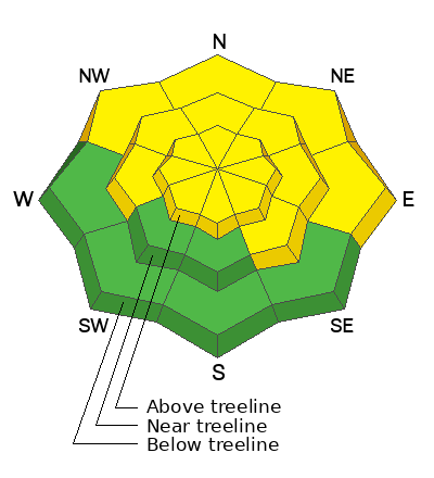
The danger remains MODERATE for triggering an avalanche on a buried persistent weak layer on slopes that face W-N-SE. Steep northerly aspects near treeline and above are most suspect where recently wind drifted snow has added more stress to this buried weak layer. Dangerous, human triggered avalanches 2'-4' deep remain possible.
Strong NW winds have blown and drifted snow creating a MODERATE danger on all aspects above treeline. Look for unstable slabs of wind drifted snow on the leeward sides of ridge crests and terrain features in wind exposed terrain.
Low
Moderate
Considerable
High
Extreme
Learn how to read the forecast here
Special Announcements
As the end of the year approaches, please consider a donation to the UAC to support avalanche forecasting.
Road Conditions: The road is snowpacked and slick. AWD and good tires are required.
Grooming: LUNA has plans to groom today.
Weather and Snow
24 Hour Snow 0" 72 Hour Snow 0" Season Total Snow 79" Base Depth at Gold Basin 40"
Winds on Pre Laurel Peak NW 5-15 Temp 19F
Weather
NW winds began to back off after midnight after blowing in the 25-35 mph range for most of the day yesterday. Cloud cover overnight has kept things warm. Today look for gradually decreasing clouds, light NW winds, and high temps in the mid 20's. No white Christmas this year I'm afraid as warmer temps and sunny skies reign through the weekend. A return to a stormy pattern mid next week is currently being advertised.

General Conditions
Strong NW winds have had their way with the snow surface and you can expect to find a combination of scoured and alternately wind loaded slopes in the alpine. You can still find nice, settled powder in sheltered locations. Recent wind loading continues to apply pressure to a buried persistent weak layer of faceted snow, particularly on steep, northerly aspects near treeline and above, and human triggered avalanches 2'-4' deep remain possible.
If you're getting out in the backcountry please let us know what you are seeing by submitting an observation . Here are the most recent observations.

Snowpack and Weather Data
Gold Basin Storm Stake (10,000')
Gold Basin SNOTEL site (10,000')
SNOTEL site near Geyser Pass Winter Trailhead (9600')
Wind Station on Pre-Laurel Peak (11,400')
NWS forecast for the La Sal Mountains.
Recent Avalanches
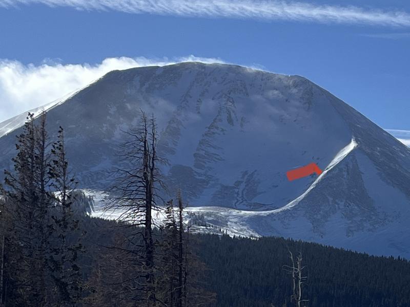
Strong northwesterly winds overloaded the shoulder on the N face of Mount Mellenthin to produce this natural avalanche sometime yesterday morning or the night before. Not particularly wide, but upwards of 3' deep, this type of problem.continues to be our primary concern. Note the completely scoured, windward side of the ridge.
Here is a complete list of avalanches in the La Sals.
Ad
Avalanche Problem #1
Persistent Weak Layer
Type
Location
Likelihood
Size
Description
A persistent weak layer of faceted snow that developed during the cold dry period in mid November exists on aspects that face W-N-SE. You are more likely to trigger an avalanche on slopes facing NW-N-E, where wind drifted snow has built thick slabs on top. These hard slabs are 1-4' thick and can produce very large, deep, and potentially deadly avalanches. The snowpack has become quiet. You will not observe obvious signs of instability as you travel today, however a poor snowpack structure still exists. This is when things get tricky. Typically during December in a continental snowpack these types of instabilities take a long time to heal. I am still traveling conservatively. If you are stepping out into moderate terrain you should do so cautiously. It is wise to avoid complex terrain and terrain traps. It is possible trigger an avalanche on:
  • Slope margins where the slab is more thin and the weight of a rider is more likely to trigger the weak layer
  • Shallow, rocky areas with a thin snowpack
  • Steep convex rollovers
You can avoid this avalanche problem by keeping your slope angles below 30 degrees, ride slopes that are heavily anchored by dense trees, or ride South facing slopes that do not harbor this dangerous persistent weak layer.
Avalanche Problem #2
Wind Drifted Snow
Type
Location
Likelihood
Size
Description
Starting late Tuesday, strong NW winds blew and drifted snow forming unstable unstable slabs on the leeward sides of ridge crests and terrain features. NW winds have a tendency to produce some unexpected loading patterns in the La Sals. Be on the lookout for fresh drifts that look fat, smooth, and rounded. Snow cracking beneath your skis is a clue that you have found a fresh drift. Newly formed wind slabs tend to be more reactive to skier triggering. Any triggered wind drift has the potential to step down and trigger a deeper and more dangerous avalanche, especially on previously loaded slopes that face NW-N-E.
Additional Information
General Announcements
This forecast is from the U.S.D.A. Forest Service, which is solely responsible for its content. This forecast describes general avalanche conditions and local variations always occur. This forecast will be updated by 7:30 tomorrow morning.