Check out our Holiday Auction - Sign Up for the Utah Snow and Avalanche Workshop (USAW)

Forecast for the Moab Area Mountains

Dave Garcia
Issued by Dave Garcia on
Thursday morning, December 22, 2022
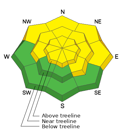
The danger remains MODERATE for triggering an avalanche on a buried persistent weak layer on slopes that face W-N-SE. Steep Northerly aspects near treeline and above are most suspect, where wind drifted snow has built slabs 2'-4' thick on top of this weak layer. The chances of triggering an avalanche have been decreasing, but these avalanches have the potential to be deep and very dangerous.
Strong NW winds continue to blow and drift snow creating a MODERATE danger for triggering fresh wind drifts on all aspects above treeline.
Low
Moderate
Considerable
High
Extreme
Learn how to read the forecast here
Special Announcements
As the end of the year approaches, please consider a donation to the UAC to support avalanche forecasting.
Road Conditions: The road is snowpacked and slick. AWD and good tires are required.
Grooming: Trails were groomed Saturday but they have seen a lot of traffic over the weekend.
Weather and Snow
24 Hour Snow 0" 72 Hour Snow 0" Season Total Snow 79" Base Depth at Gold Basin 40"
Winds on Pre Laurel Peak NW 25 G 30 Temp 15F
Weather
It is currently 15 degrees under cloudy skies in Gold Basin this morning. There is no new snow. Today will be a cold one. Temperatures at 10,000 ft will drop to the single digits. The winds will continue out of the NW at 25-30 mph. Wind chill values this morning will be sub-zero. Look for the winds back off later this afternoon. We will be under mostly cloudy skies with small chances for light snow showers through Friday. I don't expect any real accumulation. Christmas weekend looks sunny and about ten degrees warmer. Our next chance for decent snowfall will be mid week.

General Conditions
Strong winds are doing their best to wreck the snow surface. Expect to find a combination of scoured and wind loaded slopes in the alpine. You can still find nice, settled powder in sheltered locations. The avalanche danger is slowly dialing down, but a well defined persistent weak layer of faceted snow exists and the consequences of getting caught in a slide remain the same. Deep, dangerous, and potentially un-survivable human triggered avalanches remain possible, particularly on steep, northerly aspects near treeline and above.
If you're getting out in the backcountry please let us know what you are seeing by submitting an observation . Here are the most recent observations.

Snowpack and Weather Data
Gold Basin Storm Stake (10,000')
Gold Basin SNOTEL site (10,000')
SNOTEL site near Geyser Pass Winter Trailhead (9600')
Wind Station on Pre-Laurel Peak (11,400')
NWS forecast for the La Sal Mountains.
Recent Avalanches
No new avalanches have been observed. The most recent avalanches ran on or around Dec 13. Here is a complete list of avalanches in the La Sals.
Ad
Avalanche Problem #1
Persistent Weak Layer
Type
Location
Likelihood
Size
Description
A persistent weak layer of faceted snow that developed during the cold dry period in mid November exists on aspects that face W-N-SE. You are more likely to trigger an avalanche on slopes facing NW-N-E, where wind drifted snow has built thick slabs on top. These hard slabs are 1-4' thick and can produce very large, deep, and potentially deadly avalanches. The snowpack has become quiet. You will not observe obvious signs of instability as you travel today, however a poor snowpack structure still exists. This is when things get tricky. Typically during December in a continental snowpack these types of instabilities take a long time to heal. I am still traveling conservatively. If you are stepping out into moderate terrain you should do so cautiously. It is wise to avoid complex terrain and terrain traps. It is possible trigger an avalanche on:
  • Slope margins where the slab is more thin and the weight of a rider is more likely to trigger the weak layer
  • Shallow, rocky areas with a thin snowpack
  • Steep convex rollovers
You can avoid this avalanche problem by keeping your slope angles below 30 degrees, ride slopes that are heavily anchored by dense trees, or ride South facing slopes that do not harbor this dangerous persistent weak layer.
Avalanche Problem #2
Wind Drifted Snow
Type
Location
Likelihood
Size
Description
Winds have been moderate to strong out of the West for the last 24 hours. They are currently out of the NW and will blow hard enough to transport snow into fresh, sensitive drifts above treeline. NW winds have a tendency to produce some unexpected loading patterns in the La Sals. Be on the lookout for fresh drifts that look fat, smooth, and rounded. Snow cracking beneath your skis is a clue that you have found a fresh drift. Newly formed wind slabs tend to be more reactive to skier triggering. Any triggered wind drift has the potential to step down and trigger a deeper and more dangerous avalanche, especially on previously loaded slopes that face NW-N-E.
Additional Information
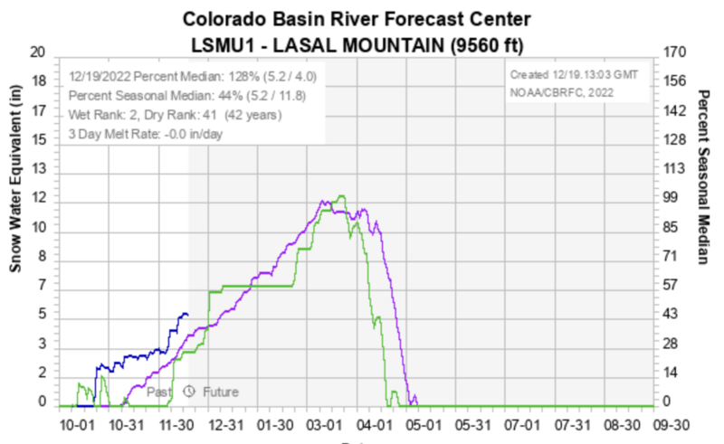
As we head into a dry period it's good to know that at least for now, we are at 128% of normal snowpack for this time of year. The blue line is where we are currently, the purple line is the average, and the green line is where we were last year at this time.
General Announcements
This forecast is from the U.S.D.A. Forest Service, which is solely responsible for its content. This forecast describes general avalanche conditions and local variations always occur. This forecast will be updated by 7:30 tomorrow morning.