Check out our Holiday Auction - Sign Up for the Utah Snow and Avalanche Workshop (USAW)

Forecast for the Moab Area Mountains

Eric Trenbeath
Issued by Eric Trenbeath on
Thursday morning, December 8, 2022
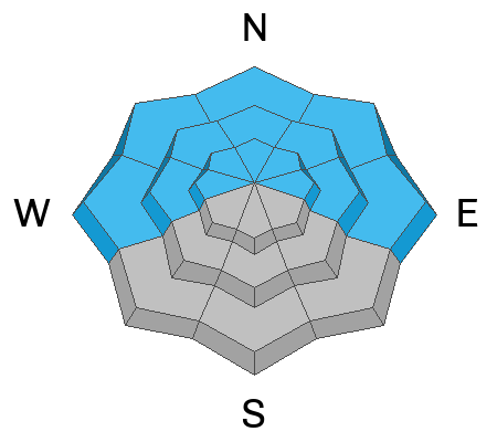
Dangerous conditions have developed and the avalanche danger is CONSIDERABLE on slopes steeper than 30 degrees that face W through N through E where a buried persistent weak layer is on the brink of being overloaded. Backcountry travelers should avoid being on or underneath steep slopes with these aspects. There is a MODERATE danger for human triggered avalanches involving the most recent snow where loose snow avalanches, or soft, cohesive slabs are possible in steep terrain. Your best bet is to stick to low angle terrain today and continue to be mindful of the low snow conditions.
Low
Moderate
Considerable
High
Extreme
Learn how to read the forecast here
Special Announcements
Road Conditions: Grand County will be plowing the road this morning. The gate will be closed while plowing is in progress.
Grooming: The Geyser Pass Road above the winter trailhead closes on Dec 15. Grooming will commence after that, but but for now, the road above the trailhead is snowpacked and well traveled and cross country ski conditions are pretty good.
Join us for the 1st Annual UAC Moab/LUNA Winter Kickoff Party on Saturday, Dec 10 at the MARC. The event will be from 7-9 PM. Get your tickets here.
The Utah Avalanche Center wants to give you free batteries for your beacons. Head on over to Moab Gear Trader to pick up your free batteries. While you are there, scan a QR code to fill out a quick survey and be entered to win some avalanche rescue gear.
Join the Utah Avalanche Center and the Division of Outdoor Recreation to celebrate the Fourth Annual Avalanche Awareness Week, from December 4 - December 11. Click HERE to view a full list of events throughout the state.
Weather and Snow
24 Hour Snow 9" 72 Hour Snow 14" Season Total Snow 55" Base Depth at Gold Basin 36"
Winds on Pre Laurel Peak W 5-10 Temp 15F
Winter has arrived with 14" of snow at around 1.5" Snow Water Equivalent (SWE) over the past 48 hours. Moderate southerly winds blew during the bulk of the storm. Today will be a gorgeous day in the mountains with fresh powder, sunny skies, light westerly winds, and high temps in the upper teens. We should see some clouds develop tonight and lingering into tomorrow as a weak, shortwave trough clips by to the north. Saturday will be mostly sunny. The next storm to affect our region begins to move in on Sunday with what looks like a decent shot of snow Sun night into Mon.
Snow depth has reached the magic number of 36" in Gold Basin which for me, signals a tentative move toward real skiing and riding. Erratic winds last week however, alternately stripped many slopes while loading others so the pattern of coverage is very uneven and many areas remain quite thin. The entire snowpack beneath the Nov 28 storm is loose, weak, and faceted and we now have 18" - 20" of snow sitting on top of that with considerably more in wind drifted areas. This translates to a poor snowpack structure and unstable snow conditions that will be with us for some time. In my travels yesterday, the snowpack was not yet talking to me and I wasn't observing the obvious signs of instability such as cracking, collapsing, or whumphing, but with the obvious poor structure, and continued snowfall, I felt we were teetering on the brink. The additional snowfall overnight should have pushed us over the edge.
Gold Basin Storm Stake (10,000')
Gold Basin SNOTEL site (10,000')
SNOTEL site near Geyser Pass Winter Trailhead (9600')
Wind Station on Pre-Laurel Peak (11,400')
NWS forecast for the La Sal Mountains.
If you are getting up into the mountains please submit an observation and let us know what you are seeing!
Recent Avalanches
A list of avalanches for the La Sal Range can be viewed here
Ad
Avalanche Problem #1
Persistent Weak Layer
Type
Location
Likelihood
Size
Description
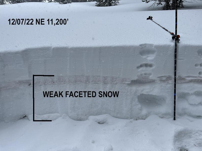
A persistent weak layer of faceted snow has developed at all elevations on aspects facing W-N-E. This was precipitated by the cold dry period in mid November, and the entire snowpack below the Nov 28 storm is loose, weak, and faceted. We are now piling a load on top of this weak foundation creating unstable conditions. You don't have to dig far down to observe this scenario, and you can even feel it by simply poking your ski pole down through the snow. On wind drifted slopes, the condition is exacerbated due to the increased load. This persistent weak layer is settling in and will be with us for awhile so plan on avoiding slopes steeper than 30 degrees that face W-N-E for the foreseeable future.
Photo illustrates the obvious poor snowpack structure. As more snow is piled on top, stress on the weak snow will increase, as will the likelihood of triggering deeper and more dangerous avalanches.
Avalanche Problem #2
New Snow
Type
Location
Likelihood
Size
Description
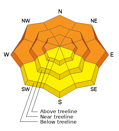
Human triggered avalanches involving the new snow are possible on steep slopes on all aspects. These may come in the form of loose snow or cohesive soft slab avalanches. If you venture on to steeper, southerly aspects to avoid the danger on northerly facing terrain, utilize test slopes to see how the snow is behaving before committing to steeper terrain. Look for signs of instability such as cracking in the snow surface.
Additional Information
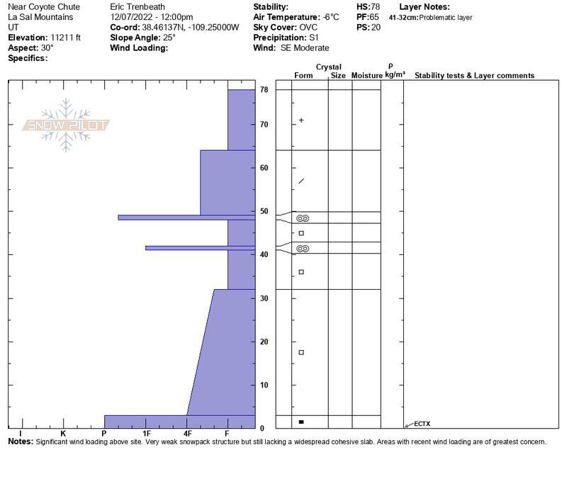
This detailed snowpit illustrates my findings on a NE aspect at 11,200'.
General Announcements
This forecast is from the U.S.D.A. Forest Service, which is solely responsible for its content. This forecast describes general avalanche conditions and local variations always occur. This forecast will be updated by 7:30 tomorrow morning.