Forecast for the Abajos Area Mountains

Issued by Eric Trenbeath on
Friday morning, December 24, 2021
Friday morning, December 24, 2021
Expect the avalanche danger to rise today and be alert to changing conditions!
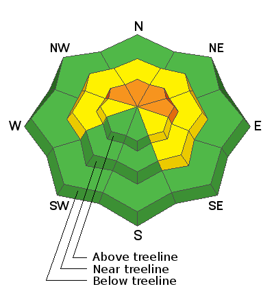
The avalanche danger starts out MODERATE this morning but will likely reach CONSIDERABLE later today as fresh deposits of wind drifted snow add stress to an underlying weak snowpack. The danger will be greatest in steep, upper elevation slopes facing NW-N-E. Human triggered avalanches will become increasingly more likely throughout the day in these areas and natural avalanches may be possible.
Most low elevation, and low and mid elevation S-SW facing terrain has a generally LOW danger.
It's also still very low tide out there. Beware of rocks, stumps, and deadfall lurking beneath the surface.

Low
Moderate
Considerable
High
Extreme
Learn how to read the forecast here


