UDOT PLANNED AVALANCHE CLOSURES!!

Forecast for the Provo Area Mountains

Trent Meisenheimer
Issued by Trent Meisenheimer on
Monday morning, December 13, 2021
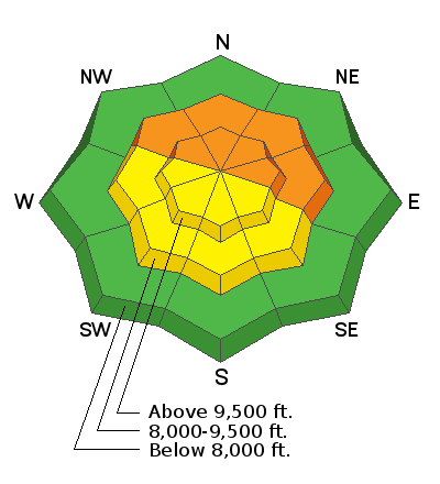
Areas of CONSIDERABLE danger exist on all steep northwest to east-facing slopes at the mid and upper elevations. This terrain is to be avoided.
You can trigger 1-3' deep avalanches today while on, above, below, or adjacent to steep terrain. Dangerous avalanche conditions exist in the backcountry.

Sensitive hard and soft wind drifts are likely to develop in steep terrain over the next 24 hours. Natural avalanches will be possible with extensive wind drifting.
Low
Moderate
Considerable
High
Extreme
Learn how to read the forecast here
Special Announcements
Watch out if traveling in the backcountry near ski areas. Please be aware of and respect their boundaries. Many resorts are working on opening their terrain and using explosives in those areas.
Batteries for Beacons runs through Dec 19. Get free batteries for your transceiver and a chance to win 1 of 10 Black Diamond Rescue Kits, 1 of 3 Mammut Barryvox transceivers, or 1 of 3 BCA Tracker transceivers. Stop at a participating shop, fill out our survey and get a free set of batteries. Don't need batteries, but still want a chance to win? Fill out the survey to be registered.
Weather and Snow
Under mostly cloudy skies, the mountain temperatures hover in the mid to low 20's °F across the board. The southwesterly winds are screaming across the upper elevation terrain (10,000') with speeds averaging 20-30 mph gusting 40-50 mph. At 11,000', the winds are southwest and blowing 35-45 mph, gusting into the 80's.
As a large-scale trough approaches Northern Utah, these southerly winds are forecasted to increase later today into tomorrow ahead of the storm. The good news is this storm will likely bring 1-2 feet of new snow to the mountains starting Tuesday afternoon/evening. Stay tuned!
Unfortunately, the southerly winds have wreaked havoc on our snow surface, making the riding and turning conditions sub-par for the course.
Recent Avalanches
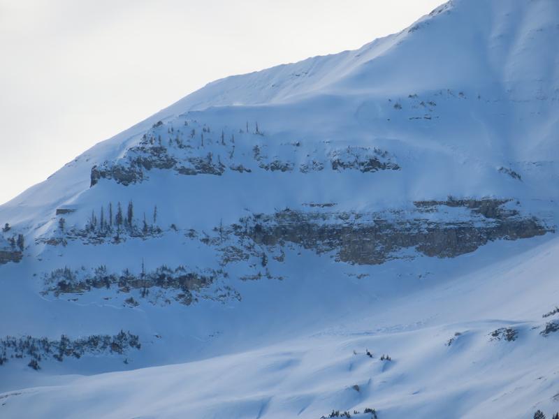
John Woodruff from the Utah Department of Transportation noted a significant avalanche cycle that either happened yesterday from the strong southerly winds or from the new snow on Friday. All of the avalanches failed from the weak faceted snow that formed back in Oct/Nov.
Many backcountry observers continue to note booming collapses and shooting cracks. Regularly check the observations page for field observations and avalanche activity.
Ad
Avalanche Problem #1
Persistent Weak Layer
Type
Location
Likelihood
Size
Description
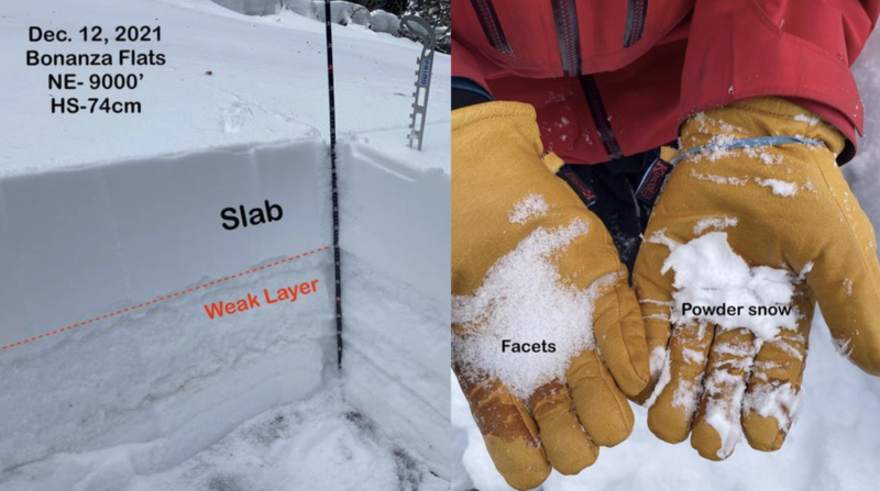
Most of the avalanches we've seen since Thursday are soft slab avalanches failing on a persistent weak layer. This interface, now 12-36" down, is a facet or facet/crust combination that will remain problematic and reactive for some time, particularly with new "loading events" (wind or snow). Today's wind will continue to stress this weak layer, and I wouldn't be surprised to hear of new avalanches.
If you're heading to slopes on the northern half of the compass, it will be essential to stick to low-angle slopes with nothing steep above you. Unfortunately, we have a dangerous snowpack right now, and we should not trust it. Avoidance is key. Remember, avalanche terrain is any slope over 30 degrees in steepness.
Photo: Torrey & Graves showing the weak faceted snow layer in their snowpit and hands.
Avalanche Problem #2
Wind Drifted Snow
Type
Location
Likelihood
Size
Description
Increasing south to southwest winds will create sensitive and stubborn wind slabs on many steep slopes, even at the mid-elevations and on mid-slope terrain features. I anticipate drifts to be primarily west to north to easterly aspects, but they may be found around the compass. Drifts are generally round and smooth and sometimes 'scalloped.' Wind drifts may break out well above you.
Note that any triggered wind slab may step down another 12-36" into older faceted weak layering from October/November, creating a much larger avalanche. Natural avalanches may be possible today.
General Announcements

This information does not apply to developed ski areas or highways where avalanche control is normally done. This forecast is from the U.S.D.A. Forest Service, which is solely responsible for its content. This forecast describes general avalanche conditions and local variations always occur.