Forecast for the Skyline Area Mountains

Brett Kobernik
Issued by Brett Kobernik on
Monday morning, March 15, 2021
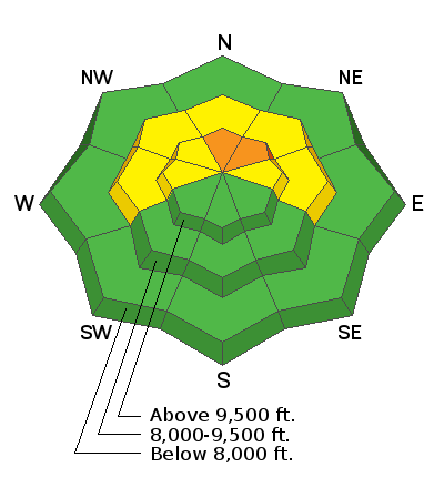
The majority of the terrain has a LOW to MODERATE avalanche danger today.
A CONSIDERABLE avalanche danger still exists in high elevation north and northeast facing steep slopes where the wind has drifted snow. It is possible to trigger an avalanche that breaks to the ground in these areas still.
Low
Moderate
Considerable
High
Extreme
Learn how to read the forecast here
Weather and Snow
Current Conditions: Clouds shrouded the high country all day on Sunday keeping riding conditions excellent but visibility poor. There was moderate speed northwest wind that was drifting snow along the more exposed locations. Overnight temperatures were in the low 20s. The northwest wind has slowed and is generally light now.
Mountain Weather: We'll see mostly cloudy to partly cloudy skies today with highs around freezing. Northwest wind should remain light and gradually shift south this afternoon. Another storm moves in tonight and will bring snow into Tuesday. This is another closed low pressure system moving down through California and will move east through Arizona tonight feeding moisture into our area. This storm is not as large as the last and is tracking a bit differently. Currently, I'm thinking we should get 3 to 6 inches of snow by Wednesday morning.
Ad
Avalanche Problem #1
Persistent Weak Layer
Type
Location
Likelihood
Size
Description
Your biggest threat today is the possibility of triggering an avalanche that breaks into old snow near the ground. The recent northwest wind that drifted snow will enhance the chances of this a bit in the higher terrain. The most likely places to trigger an avalanche will be on slopes steeper than 35 degrees that face north and northwest above around 9500 feet in elevation. The chances for triggering something are not all that great. However, I am still very leery of getting onto lots of terrain that I usually do at this time of the season.