Forecast for the Skyline Area Mountains

Brett Kobernik
Issued by Brett Kobernik on
Tuesday morning, March 16, 2021
The majority of the terrain has a LOW to MODERATE avalanche danger today.
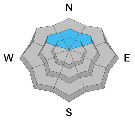
A CONSIDERABLE avalanche danger still exists in high elevation north and northeast facing steep slopes where the wind has drifted snow. It is possible to trigger an avalanche that breaks to the ground in these areas still.
We are in a "low probability/high consequence" situation. The chances for triggering an avalanche that breaks to the ground are becoming less and less but if you do, it's going to be a nasty slide.
Low
Moderate
Considerable
High
Extreme
Learn how to read the forecast here
Special Announcements
Spring Awareness Campaign - Help us save lives through avalanche forecasts and education. Consider making a donation to show your support. DETAILS HERE.
Weather and Snow
Current Conditions: There was a bit more sun mid day on Monday which took its toll on the powder making the surface damp on all sunny slopes and some northerly facing slopes. It cooled into the mid 20s overnight and a few inches of snow has fallen. The wind is generally light from the east.
Mountain Weather: A "closed low pressure system" is currently drifting east through Arizona feeding some moisture into our area in a light east flow. We should see a few more inches of snow accumulation through today. Temperatures will climb into the upper 20s. Wind will shift around to the northwest later today. We'll see partly cloudy skies and a warming trend through the end of the week.
Ad
Avalanche Problem #1
Persistent Weak Layer
Type
Location
Likelihood
Size
Description
Weak faceted loose sugary snow remains at the base of the snowpack. This remains a threat on steep upper elevation shady slopes. We just have not seen quite enough snow during the second half of the winter to compress and force the loose snow grains to bond. You can see the progression below from my snow study plot in Spring City Canyon. Everything below the dark black line is faceted snow. Over time, it has compressed and increased in strength a bit except right at the base.
Snow stability tests remain poor at this location. This location should be fairly representative of many other higher elevation shady locations around the range.