Forecast for the Logan Area Mountains

Issued by Toby Weed on
Saturday morning, March 13, 2021
Saturday morning, March 13, 2021
The snow is mostly stable, large avalanches are unlikely, and the avalanche danger is LOW in the backcountry. People still might trigger shallow slabs of wind drifted snow or loose sluffs of dry or moist surface snow on steep upper elevation slopes. Although unlikely this weekend, larger avalanches failing on a deeply buried sugary persistent weak layer remain possible in isolated very steep terrain.
Use normal caution.

Low
Moderate
Considerable
High
Extreme
Learn how to read the forecast here
 Special Announcements
Allen Foss of Preston, ID was killed in an avalanche Saturday, February 20, near Sherman Peak. Please consider supporting the Foss family during this difficult time.
 Weather and Snow
It's 25°F this morning at the 8400' Tony Grove Snotel, and there is 71 inches of total snow containing 82% of normal SWE. East winds increased again overnight and are currently blowing 42 mph and gusting to around 60 mph at the CSI Logan Peak weather station. Its 17°F with a -5°F wind chill value at 9700' this morning. We're expecting a chance of snow showers again today, but mostly sunny skies, high temperatures at 8500' around 33°F, and steady and fairly strong northeast winds. It'll be a bit warmer tomorrow and mostly sunny, and winds from the west-northwest will be a bit lighter. Cool and unsettled weather will continue into next week, with snow showers possible tomorrow, but not much in the way of accumulation likely.
We found stable snow conditions and Low avalanche danger in Wood Camp Hollow yesterday.
 Recent Avalanches
A party of riders reports triggering a few shallow loose avalanches of dry snow or sluffs on steep slopes in the Northern Bear River Range. These were manageable, but they had to be aware and careful of the trees below.

Sluffs of fresh snow on a steep slope in the Northern Bear River Range. (Flygares, 3-12-2021)
-It's been nearly two weeks since any human triggered or natural avalanches failing on our nasty widespread buried persistent weak layer occurred.
-A very extensive natural avalanche cycle occurred in mid February, and evidence is still apparent across the zone including deep crown lines, large chunks and very long piles of avalanche debris.
Avalanche Problem #1
Normal Caution
Type
Location

Likelihood
Size
Description
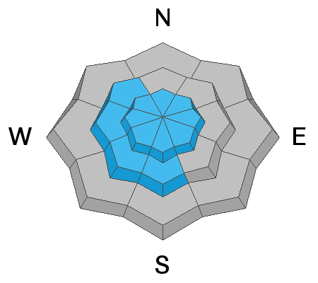
- Although suspect persistent weak layers appear to be dormant, the sugary faceted snow near the ground will probably continue to be devious on some slopes. Dangerous avalanches, 2 to 4 feet deep probably remain possible for people to trigger on very steep isolated slopes, in rocky terrain, and on a few outlying drifted slopes with generally thin snow cover.
- East winds have been blowing for the past couple days and they increased again overnight, drifting a few inches of fresh snow and depositing shallow wind slabs in perhaps unusual or unexpected places at upper elevations. These will be stiffer today and still generally manageable, but some may be sensitive to your weight and could pick up speed running on a thick and slippery melt-freeze crust.
- Loose avalanches or sluffs of dry or moist surface snow are possible in steep terrain where a few inches of snow accumulated this week. Watch for trees or other terrain traps below you if you venture onto steep slopes.
Additional Information
Do you have the essential avalanche rescue gear (transceiver, probe, and shovel) and do you know how to use them? Watch this video to see how the three pieces of equipment work together. HERE
Please keep practicing with the Beacon Training Park at the Franklin Basin Trailhead. Test yourself and your riding partners. It is free, fun, and easy to use.
General Announcements
Visit this website with information about Responsible Winter Recreation by the Utah Office of Outdoor Recreation.
EMAIL ADVISORY. If you would like to get the daily advisory by email you subscribe HERE.
Remember your information can save lives. If you see anything we should know about, please help us out by submitting snow and avalanche observations....HERE. You can also call us at 801-524-5304, email by clicking HERE, or include #utavy in your Instagram, or @UAClogan on Twitter.
We will update this forecast by around 7:30 Monday morning.
This forecast is from the USDA Forest Service, which is solely responsible for its content. The forecast describes general avalanche conditions and local variations always occur.


