


Forecast for the Abajos Area Mountains
Issued by Chris Benson on
Tuesday morning, March 9, 2021
Tuesday morning, March 9, 2021
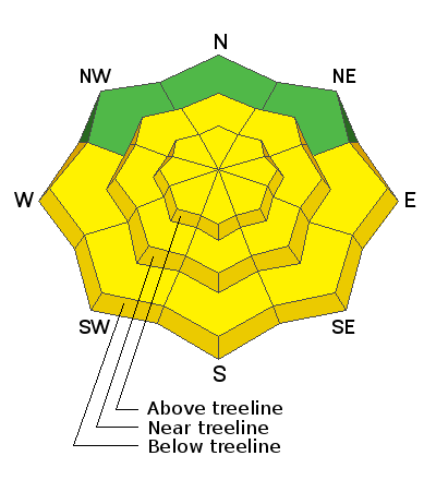
The avalanche danger remains MODERATE. Deep and dangerous human-triggered avalanches failing on a buried persistent weak layer remain the primary concern. These are becoming a low probability/high consequence problem. You are most likely to trigger one of these avalanches on steep terrain near and above treeline that faces NW through N through SE. Thin snowpack areas around rock outcroppings, sparse trees, or along slope margins are the most likely trigger points. As the day heats up we may some loose wet activity on sun-exposed slopes. Look for signs of instability such as roller balls and pinwheels, and get off of and out from under steep slopes if they become wet and sloppy.
Low
Moderate
Considerable
High
Extreme
Learn how to read the forecast here
 Special Announcements
 Weather and Snow
Southwest flow ahead of a strong low pressure system will bring increasing clouds, a high near 37 F (10,000'), and southwest winds ranging from 20-30 mph with gusts into the 50 mph range. Overnight temps remained warm and it barely froze at 10,000', making this the third night in a row without refreezing. Yesterday and overnight, southerly winds ranged from 25-50 mph. Looking towards the end of the week, the low pressure system is expected to make its way into the desert southwest bringing cooler and unsettled weather for the rest of the week starting tomorrow evening.
Snow totals at Buckboard Flat (8924')
Snow totals at Camp Jackson (8858')
Snowpack Discussion
Warm temperatures are promoting bonding and consolidating the snowpack, but without overnight refreezes, sunny, lower elevation areas contain weak snow. Avoid slopes that do not have a supportable crust and check for moist snow underneath thin crusts. Today with high clouds, we may see a bit of a greenhouse effect and many slopes will become dangerously weak, producing loose wet avalanches or possibly wet slab avalanches.
Strong winds have kept upper-elevation slopes cool, however, this is where you can find newly formed wind-drifts resting on fragile weak layers of faceted snow, primarily NW-N-E-SE. We are moving toward a low probability/high consequence situation for deep and dangerous avalanches. Weak, faceted snow can still be found on most aspects and stiff, hard slabs 1'-3' thick exist over this weak layer on slopes facing primarily NW-N-E-SE. Shallow areas, along slope margins and near rock outcroppings or sparse trees remain likely trigger points.
Additional Information
Information on outdoor recreation - The State of Utah created this webpage with information about recreating on both state and federal public lands during the current health crisis.
New to the backcountry (including riding at closed resorts) - Watch the award-winning, 15 minute Know Before You Go video, or take the 5-part, free online-learning series.
General Announcements
This forecast is from the U.S. Forest Service, which is solely responsible for its content. This forecast describes general avalanche conditions and local variations always occur.