Forecast for the Abajos Area Mountains

Eric Trenbeath
Issued by Eric Trenbeath on
Thursday morning, February 11, 2021
The avalanche danger is MODERATE though you can still trigger deep and dangerous avalanches on steep slopes facing NW-N-SE. Above treeline, wind-loading over the past week has added additional stress to buried, persistent weak layers. As a result, the danger increases with elevation, as does the likelihood of triggering an avalanche. Less likely, but not impossible, are avalanches failing on drifted slopes with a more southerly aspect. Please consider what a MODERATE risk for dying really means. This is far from a green light, and unless you like playing Russian Roulette, continue to avoid steep, northerly facing terrain.
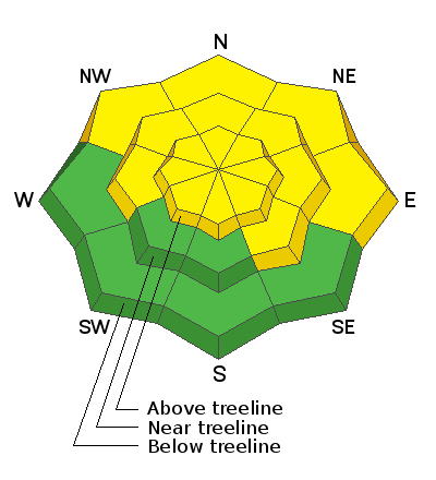
Low
Moderate
Considerable
High
Extreme
Learn how to read the forecast here
Special Announcements
We are filled with grief to report four fatalities from a skier triggered avalanche in the Wasatch Mountains on Saturday. All were well known members of the backcountry community. Here is the preliminary report. Additionally, yet another avalanche fatality has occurred in WA; preliminary report. In a little over a week, there have been 16 avalanche fatalities across the U.S. Conditions are dangerous in most regions and ours is no exception. Please stay conservative in your terrain choices.
Weather and Snow
The mountains picked up a couple inches of snow yesterday and WNW winds were mostly light. They've shifted to the SW early this morning and have bumped up into the teens with gusts to 20 mph along ridgetops. Today will be the last sunny day for a while as an active weather pattern is lining up out in the Pacific. The first system to move through on Friday looks to favor the northern mountains but we could see 2"-4". A better chance for higher amounts comes from the next system to move through late Saturday into Sunday. Active weather continues into next week.
Snow totals at Buckboard Flat (8924')
Snow totals at Camp Jackson (8858')
Snowpack Discussion
Conditions are variable. Snow depths range from 2'-4' deep on northerly aspects while coverage on south-facing terrain remains quite thin with some slopes continuing to show bare ground. The sparse coverage makes conditions deceiving, but dangerous human triggered avalanches remain possible on steep, northerly facing slopes. In these areas, the underlying snow is very weak and sugary and is providing an unstable base for slabs that have formed on top.
Chris Benson was up yesterday and sent in this observation.
He also shot this drone footage that details snow cover and an old avalanche.
Recent Avalanches
A relatively recent avalanche in the La Sals provides a look into the similarly poor snowpack structure of the Abajos.
Additional Information
Information on outdoor recreation - The State of Utah created this webpage with information about recreating on both state and federal public lands during the current health crisis.

New to the backcountry (including riding at closed resorts) - Watch the award-winning, 15 minute Know Before You Go video, or take the 5-part, free online-learning series.
General Announcements
This forecast is from the U.S. Forest Service, which is solely responsible for its content. This forecast describes general avalanche conditions and local variations always occur.