


Forecast for the Abajos Area Mountains
Issued by Chris Benson on
Friday morning, January 29, 2021
Friday morning, January 29, 2021
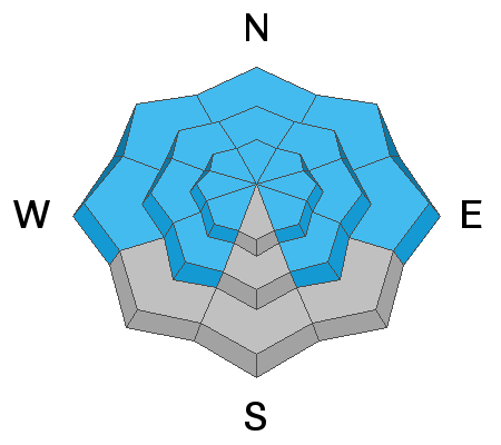
Strong southerly winds have overloaded north-facing slopes and the avalanche danger is CONSIDERABLE on steep slopes facing W-N-E at upper elevations. Human triggered avalanches are likely, and natural avalanches are possible in these areas. Cautious route-finding and conservative decision-making are essential. Elsewhere, the avalanche danger is MODERATE and human-triggered avalanches are possible. Stay off of and out from under steep, northerly-facing avalanche terrain.

Low
Moderate
Considerable
High
Extreme
Learn how to read the forecast here
 Special Announcements
Do you have the essential avalanche rescue gear (transceiver, probe, and shovel) and do you know how to use them? Watch this video to see how the three pieces of equipment work together.
 Weather and Snow
Yesterday, southerly winds blew in the 25-35 mph range for most of the day. While these winds were consistent, there was not much snow to transport and the forecasted winds failed to materialize. Today, southwest flow overhead will strengthen, driving the deep pacific trough into our area. Look for increasing clouds throughout the day and high temps near 30F. Southwesterly winds will continue to increase, ranging from 30 to 40 mph with gusts to around 50 mph. Isolated rain and snow showers could occur by midday, but the main pulse will occur tonight, with ensemble models estimating 3-5" of snow for the La Sal and Abajo Mountains.
Snow totals at Buckboard Flat (8924')
Snow totals at Camp Jackson (8858')
Snowpack Discussion
A significant load of snow combined with wind has created dangerous avalanche conditions in the Abajo Mountains. The underlying snowpack is very weak and is comprised of loose, sugary faceted snow. Dense drifts and slabs now overly this poor snowpack structure and conditions are unstable. In our travels yesterday in the La Sals, the impacts of Wednesday's wind event were evident and can be expected to be found in the Abajos as well. In areas below treeline, last weekend's storm snow is less wind-affected. Near treeline, depth is variable and much of the snow has been stiffened by the wind. In these areas, the snow is more supportive and we experienced less cracking and collapsing than we had expected. In areas that have wind-drifted snow, the snowpack is considerably deeper with a moderately dense slab (4F to 1F hardness) overlying weak basal facets (F hardness) above the October and November crusts. Above treeline, large wind drifts and significant cross loading were easily observed on leeward aspects, ranging from west to north to east. Poor snowpack structure still plagues our mountains, with numerous persistent weak layers buried both underneath recent snow, as well as near the bottom of the snowpack. Strong winds have built stiff slabs on these weak layers and may be triggered by the weight of a skier or rider, especially in places where the slab is thin and weak.
 Recent Avalanches
Mathew Cozart reported observing several avalanches yesterday. Read his report here. Hopefully more information on the character and timing of these avalanches is forthcoming. In any event, they are "bullseye" information that the snowpack is unstable.
Avalanche Problem #1
Persistent Weak Layer
Type
Location
Likelihood
Size
Description
Almost 2.6" of snow-water-equivalent has graced the Abajos since last Friday, essentially doubling the entire snowpack. This slab rests on a variety of weak layers formed earlier in the season.
Avalanche Problem #2
Wind Drifted Snow
Type
Location
Likelihood
Size
Description
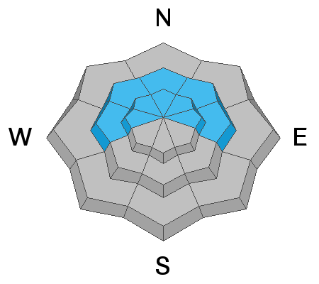
Strong southerly winds earlier this week have redistributed snow onto northerly aspects.
Additional Information
Information on outdoor recreation - The State of Utah created this webpage with information about recreating on both state and federal public lands during the current health crisis.
New to the backcountry (including riding at closed resorts) - Watch the award-winning, 15 minute Know Before You Go video, or take the 5-part, free online-learning series.
General Announcements
This forecast is from the U.S. Forest Service, which is solely responsible for its content. This forecast describes general avalanche conditions and local variations always occur.