Forecast for the Abajos Area Mountains

Eric Trenbeath
Issued by Eric Trenbeath on
Thursday morning, January 28, 2021
Strong southerly winds have dangerously overloaded north-facing slopes and the avalanche danger is HIGH on steep slopes facing NW-N-E at upper elevations. Human triggered avalanches are very likely if not certain, and natural avalanches are possible in these areas. At mid and lower elevations the avalanche danger is CONSIDERABLE and human-triggered avalanches are likely. Backcountry travelers need to have excellent route finding skills. Stay off of and out from under steep, northerly-facing avalanche terrain. Most south-facing terrain has a MODERATE danger.
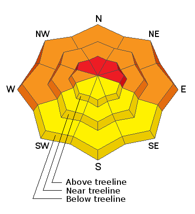
Low
Moderate
Considerable
High
Extreme
Learn how to read the forecast here
Special Announcements
Do you have the essential avalanche rescue gear (transceiver, probe, and shovel) and do you know how to use them? Watch this video to see how the three pieces of equipment work together.
Weather and Snow
The story is the wind. Strong southerly winds blew in the 25-35 mph range all day yesterday. They backed off slightly overnight but are on the rise again this morning and will continue to increase throughout the day. Skies will be mostly cloudy and high temps will be near 30F. Remnants of an atmospheric river and associated low that has slammed California will move onshore and begin to move across the Great Basin tomorrow. With most of the energy diminished from this powerful system, we're likely to only see a few inches of snow Friday night. High pressure builds on Sunday with models suggesting another system moving into the region mid-week.
Snow totals at Buckboard Flat (8924')
Snow totals at Camp Jackson (8858')
Snowpack Discussion
A significant load of snow combined with wind has created dangerous avalanche conditions in the Abajo Mountains. The underlying snowpack is very weak and is comprised of loose, sugary faceted snow. Dense drifts and slabs now overly this poor snowpack structure and conditions are very unstable. Mathew Cozart was up again Wednesday and he reported deep snow with widespread signs of instability such as cracking and collapsing on northerly aspects. Read his report here.
Additional Information
Information on outdoor recreation - The State of Utah created this webpage with information about recreating on both state and federal public lands during the current health crisis.

New to the backcountry (including riding at closed resorts) - Watch the award-winning, 15 minute Know Before You Go video, or take the 5-part, free online-learning series.
General Announcements
This forecast is from the U.S. Forest Service, which is solely responsible for its content. This forecast describes general avalanche conditions and local variations always occur.