Forecast for the Skyline Area Mountains

Brett Kobernik
Issued by Brett Kobernik on
Sunday morning, January 3, 2021
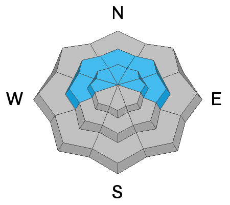
Steep upper elevation west, north and east facing slopes have a CONSIDERABLE avalanche danger. If you avoid that terrain, the avalanche danger is much lower. Human triggered avalanches breaking into weak snow near the ground are likely.
The truth is most people will find it difficult to actually get into avalanche terrain because of how shallow the snowpack is. I really don't expect any trouble until we get some more snow and the cover is better allowing for easier travel.
Low
Moderate
Considerable
High
Extreme
Learn how to read the forecast here
Weather and Snow
Current Conditions: The westerly wind picked up on Saturday and blew snow around creating some crusts and drifts. It wasn't real strong but certainly noticeable. Surface conditions have deteriorated some due to the wind. Overnight, temperatures were in the upper teens and the wind is still a bit breezy from the west.
Mountain Weather: We'll see clouds today with the chance for light snow. No real accumulation is expected beyond a trace to an inch or so possible. Highs will be in the low 20s. Wind will be moderate in speed from the west and northwest. Another disturbance will move through Monday night into Tuesday which might bring 2 to 4 inches of new snow. The next small storm rolls through around Friday which looks like it might be good for a few inches of new snow.
Ad
Avalanche Problem #1
Persistent Weak Layer
Type
Location
Likelihood
Size
Description
The weak snow near the ground is still there and it's not getting any stronger. Currently, collapsing of the snowpack is occurring less than earlier this week. This means that avalanches will be harder to trigger also but I wouldn't screw around with it. A buried Persistent Weak Layer of sugary facets will bite you long after you might think things are safe.