Get Your Ticket to the 32nd Annual Backcountry Benefit on September 11th! Support Forecasting, Awareness, and Education
Ad

Forecast for the Skyline Area Mountains

Brett Kobernik
Issued by Brett Kobernik on
Saturday morning, January 2, 2021
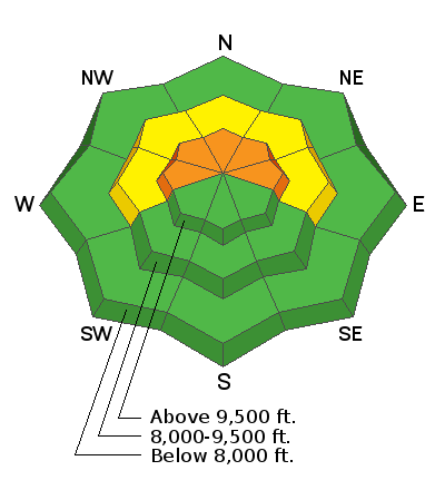
Windy conditions today along the higher terrain may transport enough snow to increase the avalanche danger slightly. A CONSIDERABLE danger still exists in the upper elevation west, north and east facing slopes. At this point in time, not all steep slopes that people get onto will avalanche. The problem is, it is difficult to know which slopes will and which won't avalanche.
Low
Moderate
Considerable
High
Extreme
Learn how to read the forecast here
Special Announcements
Weather and Snow
Current Conditions: The snow surface is good for skiing and snowboarding but there's not really enough to do much more than ride roads with snowmobiles. Northwest wind has increased overnight along the highest locations. As of now, it is still pretty light in the mid elevations. Overnight temperatures were in the mid teens to around 20˚F. Below is a video of some fieldwork from Friday.
Mountain Weather: Clouds this morning should dissapate some during the day and high temperatures will be around 20˚F. It looks a little breezy from the northwest along the high terrain today. Sunday looks a little more cloudy and a bit breezy from the southwest with slightly cooler temperatures. A small storm will move through on Monday/Monday night which might bring 3 to 6 inches of snow. Weather models have really backed off of once advertised larger snow amounts over the next week. It looks like it's possible that we'll still see some snow but nothing too exciting as of now.
Ad
Avalanche Problem #1
Persistent Weak Layer
Type
Location
Likelihood
Size
Description
The weak sugary snow near the ground is still present and will continue to cause concern for some time to come. During fieldwork on Friday, my partner and I did not experience near the amount of collapsing that we did earlier this week. The snowpack is adjusting to its current state and while it is less likely that someone will trigger an avalanche, the situation is still quite unpredictable as to which slopes will slide and which won't. It's a roll of the dice in the upper elevation steep west, north and east facing slopes.