Forecast for the Abajos Area Mountains

Eric Trenbeath
Issued by Eric Trenbeath on
Monday morning, December 28, 2020
An approaching storm system will likely increase the avalanche danger over the next 24 hours as new and wind drifted snow threaten to overload an underlying, weak snowpack. The avalanche danger is MODERATE today, but may increase to CONSIDERABLE sometime tonight and into tomorrow on steep slopes facing NW-N-E. In these areas fresh wind drifts will develop on top of layers of weak, sugary, faceted snow. Overall low coverage makes it very difficult to access avalanche terrain at this time, but if you find yourself in these areas, suspect slopes that have smooth, rounded deposits of wind drifted snow. Cracking, whumphing, or collapsing of the snowpack are signs of instability. Even a small avalanche triggered under these conditions can have serious and painful consequences.
Low
Moderate
Considerable
High
Extreme
Learn how to read the forecast here
Weather and Snow
The first significant storm system we've seen in a while is moving into the region although it doesn't look like a big producer for the Abajos. 4"-8" are possible. Look for light snow showers to begin mid-morning with 2"-4" possible today. Southerly winds will be on the increase averaging 20-25 mph along ridgetops with gusts to 40 mph. High temps will be in the mid 20's. The main energy will arrive this evening with snowfall continuing through tonight with another 2"-4". Snow will taper off by Tuesday morning as the storm exits the area.
Snowpack Discussion
Coverage is exceedingly thin and many sun-exposed slopes are dry. On shady aspects, depths range from 6"-18". The existing snow structure is very poor. In exposed areas, stiff slabs overly this weak, sugary snow, and we experienced frequent cracking and collapsing of the snowpack. These are clear red flag signs of instability. Places you could trigger an avalanche include steep drifted, gully walls, or shady slopes with continuous coverage, where more than about a foot of snow exists.
Snow totals at Buckboard Flat (8924')
Snow totals at Camp Jackson (8858')
Recent Avalanches
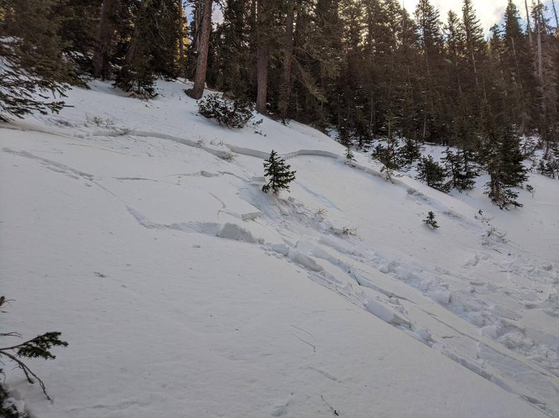
Dustin Randall from ROAM Industry sent in this photo of an avalanche he remotely triggered on a steep, northerly facing slope near 10,000' last week. In spite of the low snow conditions, the existing, underlying snow is very weak, and anywhere that a slab exists on top, is primed and ready for an avalanche. This is exactly the type of setup we are concerned with right now and additional snow will only exacerbate the problem.
Additional Information
Information on outdoor recreation - The State of Utah created this webpage with information about recreating on both state and federal public lands during the current health crisis.

New to the backcountry (including riding at closed resorts) - Watch the award-winning, 15 minute Know Before You Go video, or take the 5-part, free online-learning series.
General Announcements
This forecast is from the U.S. Forest Service, which is solely responsible for its content. This forecast describes general avalanche conditions and local variations always occur.