Forecast for the Skyline Area Mountains

Brett Kobernik
Issued by Brett Kobernik on
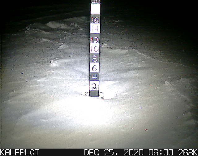
Friday morning, December 25, 2020
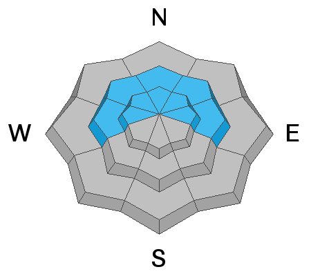
You can travel around in the mountains safely if you avoid steep upper elevation more northerly facing terrain. However, northwest, north and northeast facing steep slopes still have a CONSIDERABLE avalanche danger. Human triggered avalanches are likely in this terrain.
Low
Moderate
Considerable
High
Extreme
Learn how to read the forecast here
Weather and Snow
Current Conditions: The photo above shows the skiff of snow from Tuesday. You can also see that the snow has been affected by the wind. Despite not getting much new snow and some stronger wind, there is some decent snow for riding right now. Temperatures remain cold and are in the single digits this morning. Ridgetop temperatures are in the mid 20s. It's colder in the canyon bottoms with many stations in the teens. The wind speed is light from the southwest.
Mountain Weather: We'll have very mild weather today in the mountains with highs right around freezing. Wind will be pretty light from the south. Looks like we'll see clouds move in for the weekend with the chance for light snow. A more organized storm is shaping up for Monday which might bring us 4 to 8 inches of snow.
Ad
Avalanche Problem #1
Persistent Weak Layer
Type
Location
Likelihood
Size
Description
  • There is a layer of weak faceted sugary snow near the ground with newer snow on top of it. This is a poor snowpack structure.
  • Collapsing (WHOOMPING) of the snowpack continues. This is the weak faceted snow on the ground collapsing under the newer snow.
  • Wind has drifted snow recently.
These are all Red Flags for avalanches. This stuff indicates avalanches are possible.