Forecast for the Skyline Area Mountains

Brett Kobernik
Issued by Brett Kobernik on
Thursday morning, December 24, 2020
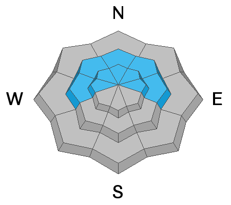
Upper elevation steep more northerly facing slopes are still dangerous. A CONSIDERABLE danger exists and human triggered avalanches are likely. If you avoid the upper elevation steep shady slopes, the danger is much lower and you can travel around without being worried you'll trigger an avalanche.
Low
Moderate
Considerable
High
Extreme
Learn how to read the forecast here
Weather and Snow
Current Conditions: Temperatures remain cold and are in the single digits this morning. The stiff northwest wind has let up and is light to moderate in speed from the west. The snowpack remains very shallow which greatly limits travel.
Mountain Weather: Warmer air moves in today and we'll see plenty of sun. Christmas Day is even warmer. It looks like we'll start seeing some chances starting this weekend with the best accumulations happening Monday night. The storm is currently looking like it may bring 4 to 8 inches of new snow. There are more small storms lined up over the next couple of weeks.
Ad
Avalanche Problem #1
Persistent Weak Layer
Type
Location
Likelihood
Size
Description
Snow that fell in November became weak during a long stretch of high pressure which lasted into early December. That snow is faceted and loose. We now have more snow on top of it and that old snow is acting as a weak layer. This situation will continue to cause avalanches for the foreseeable future.