

Forecast for the Moab Area Mountains

Issued by Eric Trenbeath on
Saturday morning, March 21, 2020
Saturday morning, March 21, 2020
New and wind drifted snow have begun to dangerously overload a weak snowpack, and the avalanche danger remains CONSIDERABLE. Human triggered avalanches 2' - 4' deep are likely on steep slopes facing NW-N-E. On all other aspects, the avalanche danger is MODERATE and human triggered avalanches are possible. Backcountry travelers need to have excellent route finding skills today. Keep your expectations low and stick to low angle, wind-sheltered terrain.
Low
Moderate
Considerable
High
Extreme
Learn how to read the forecast here
 Special Announcements
We know there is a lot of uncertainty regarding the Coronavirus, but the Utah Avalanche Center is planning to continue issuing regular avalanche forecasts into April.
Road Conditions: Plowing on Thursday was minimal and the road is narrow and the parking lot is a mess.
Grooming: Trails have not been groomed.
 Weather and Snow
24 Hour Snow 6" Weekly Snow 19" Base Depth in Gold Basin 72" Wind SE 10-15 mph Temp 14F
Wind, temperature, humidity on Pre Laurel Peak (11,700')
Storm totals at Gold Basin Study Plot (10,000').
Snotel site near Geyser Pass Trailhead (9600').
NWS weather forecast
Weather: Snow continued to fall throughout the day yesterday adding another 4"-6" and bringing totals up to 19" in Gold Basin. Reports from up around Geyser Pass are of 2' or more of new snow. SE winds were pretty well behaved yesterday averaging just 15 mph but with regular gusts into the upper 20's. Today look for mostly cloudy skies and scattered snow showers. Southerly winds will be mostly light and high temps will be in the upper 20's. We should see mostly sunny skies tomorrow before the next system moves into the region on Monday. Hello Spring!
Snowpack: Powder conditions have returned to the La Sal Mountains but new and wind drifted snow is piling up on a fragile snowpack that is comprised largely of weak, sugary, faceted snow. Weak snow can be found on all aspects and with up to 2' of new snow, all slopes steeper than 35 degrees should be considered suspect. The greatest danger exists however on steep, wind loaded slopes that face the north half of the compass where the underlying snowpack is exceedingly weak. I know we've been in a powder drought for awhile, but now is the time to temper your enthusiasm.
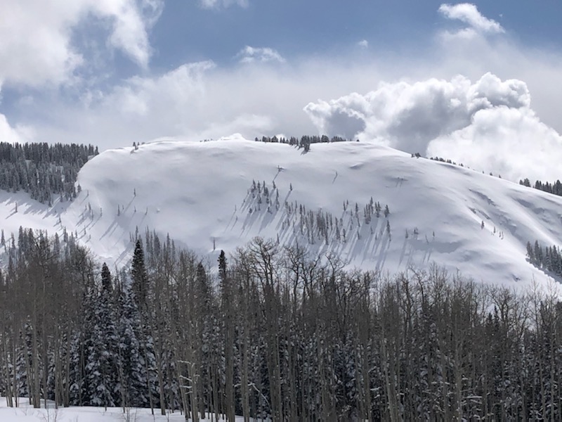
Brett Sutteer sent in this photo he managed to snap during a brief period of clearing. This ominous looking, wind loaded slope is definitely the kind of terrain you want to avoid.
 Recent Avalanches
I received a report of two skiers being partially buried in an avalanche yesterday. I don't have any other details.
Casey Bateman reported a natural avalanche in Exxon's Folley. Though visibility was poor, he said it was large, with a fracture up to 2' deep, possibly stepping down into old, weak, faceted snow. Read his report here.

Avalanche Problem #1
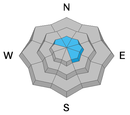
Persistent Weak Layer
Type
Location
Likelihood
Size
Description
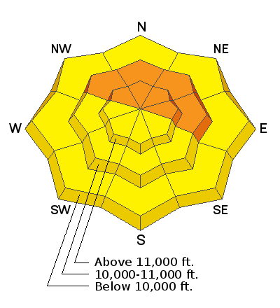
Recent and wind drifted snow have begun to dangerously overload the layers of weak, sugary, faceted snow that comprises much of the snowpack. You are most likely to trigger an avalanche involving these persistent weak layers on steep, wind loaded, northerly facing slopes right around treeline, or in shallower, rocky areas in the alpine. Whumphing and collapsing in the snowpack are indicators of this type of instability.
Avalanche Problem #2
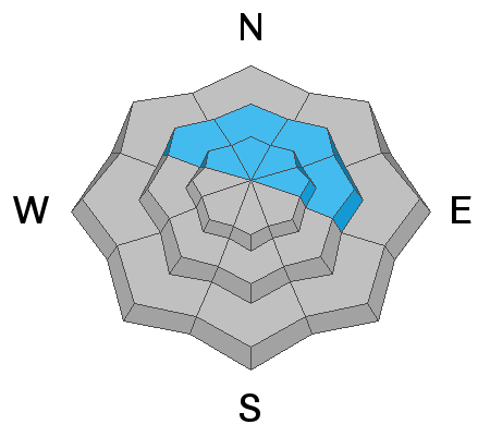
Wind Drifted Snow
Type
Location
Likelihood
Size
Description
Southerly winds have blown and drifted snow on to northerly aspects right around treeline and above. Look for fresh drifts on the leeward sides of ridge crests and terrain features in upper elevation, wind exposed terrain. Fresh drifts are recognizable by their smooth, rounded appearance and cracking is a sign of instability. In these same areas, a triggered wind slab could step down into a buried persistent weak layer causing a deeper and more dangerous avalanche. Avoid steep, wind loaded slopes today.
Avalanche Problem #3
New Snow
Type
Location

Likelihood
Size
Description
Avalanches within the most recent snow remain possible today on steep slopes on all aspects with the danger increasing the higher you go. These avalanches may take the form of loose snow sluffs or soft, cohesive slabs. Look for signs of instability such as recent avalanches, sluffing, or cracking in the snow surfaces.
General Announcements
Check out the avalanche beacon training park at the Geyser Pass Trailhead and practice your rescue skills!
This forecast is from the U.S. Forest Service, which is solely responsible for its content. This forecast describes general avalanche conditions and local variations always occur.