Forecast for the Moab Area Mountains

Eric Trenbeath
Issued by Eric Trenbeath on
Friday morning, March 20, 2020
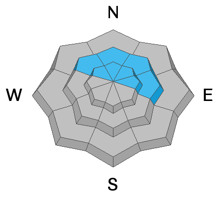
The avalanche danger remains CONSIDERABLE on steep slopes facing NW-N-E where human triggered avalanches involving new and wind drifted snow are likely. In these same areas, human triggered avalanches failing on a buried persistent weak layer of loose, sugary, faceted snow are also likely. On all other aspects, the danger is MODERATE for avalanches involving the most recent storm snow. Backcountry travelers need to have excellent route finding skills today. Stick to low angle, wind-sheltered terrain.
Low
Moderate
Considerable
High
Extreme
Learn how to read the forecast here
Special Announcements
We know there is a lot of uncertainty regarding the Coronavirus, but the Utah Avalanche Center is planning to continue issuing regular avalanche forecasts into April.
Road Conditions: Grand County plowed yesterday.
Grooming: Trails have not been groomed.
Weather and Snow
24 Hour Snow 4" Weekly Snow 17" Base Depth in Gold Basin 68" Wind SE 10-15 mph Temp 19F
Wind, temperature, humidity on Pre Laurel Peak (11,700')
Storm totals at Gold Basin Study Plot (10,000').
Snotel site near Geyser Pass Trailhead (9600'). l
Weather: Snow totals from yesterday's storm came in at 13" with likely higher amounts at upper elevations. SW winds steadily decreased yesterday before switching to the SE around midnight. Today look for mostly cloudy skies and a chance for a few inches of snow from convective showers. Southerly ridgetop winds will average 15-20 mph, and high temps will be in the upper 20's. Unsettled weather continues through tomorrow with what looks like another 2"-4" possible by afternoon. Brief ridging moves in making for mostly sunny skies on Sunday before the next low-pressure system moves into the region on Monday.
Snowpack: It should be a good day up there with more than a foot of new snow. However, up to 20" of snow over the past week and strong southerly winds have built thick slabs over the weak, sugary, facets that make up much of the snowpack. Casey Bateman and Tim Mathews both sent in observations from their travels yesterday. They reported good turning conditions with little sign of instability in the most recent snow. Wind loading was observed and and concerns for persistent weak layers were noted. Read their observations here.
Recent Avalanches
Casey Bateman reported a natural avalanche in Exxon's Folley. Though visibility was poor, he said it was large, with a fracture up to 2' deep, possibly stepping down into old, weak, faceted snow. Read his report here.
Ad
Avalanche Problem #1
Wind Drifted Snow
Type
Location
Likelihood
Size
Description
Southwesterly winds have blown and drifted snow on to northerly aspects right around treeline and above. Look for fresh drifts on the leeward sides of ridge crests and terrain features in upper elevation, wind exposed terrain. Fresh drifts are recognizable by their smooth, rounded appearance and cracking is a sign of instability. In these same areas, a triggered wind slab could step down into a buried persistent weak layer causing a deeper and more dangerous avalanche. Avoid steep, wind loaded slopes today.
Avalanche Problem #2
Persistent Weak Layer
Type
Location
Likelihood
Size
Description
Recent and wind drifted snow has provided enough of a load to affect the layers of weak, sugary, faceted snow that comprises much of the snowpack. You are most likely to trigger an avalanche involving these persistent weak layers on steep, wind loaded, northerly facing slopes right around treeline and below, or in shallower, rocky areas in the alpine. Whumphing and collapsing in the snowpack are indicators of this type of instability.
Avalanche Problem #3
New Snow
Type
Location
Likelihood
Size
Description
Avalanches within the most recent snow remain possible today on steep slopes on all aspects with the danger increasing the higher you go. These avalanches may take the form of loose snow sluffs or soft, cohesive slabs. Look for signs of instability such as recent avalanches, sluffing, or cracking in the snow surfaces.
General Announcements
Check out the avalanche beacon training park at the Geyser Pass Trailhead and practice your rescue skills!
This forecast is from the U.S. Forest Service, which is solely responsible for its content. This forecast describes general avalanche conditions and local variations always occur.