


Forecast for the Moab Area Mountains

Issued by Eric Trenbeath on
Monday morning, February 24, 2020
Monday morning, February 24, 2020
Northwest winds overnight have blown and drifted snow increasing the danger to MODERATE on steep slopes that have recent deposits of wind drifted snow. Look for fresh, unstable drifts on the leeward sides of ridge crests and terrain features right around treeline and above. Fresh drifts are recognizable by their smooth rounded appearance and cracking is a sign of instability. Most non-wind affected slopes have generally LOW danger.

Low
Moderate
Considerable
High
Extreme
Learn how to read the forecast here
 Special Announcements
The UAC's Avy Awareness Auction is currently underway with tons of great gear, jewelry, artwork and experiences available. Visit the auction page here to help support the UAC's spring avalanche awareness and outreach efforts.
A new version of the UAC IOS application is now available on the Apple App Store. This version fixes many of the issues that occur when running IOS 13.
Road Conditions: The most recent snow has been well packed in by traffic. The road is slick and icy in places.
Grooming report: LUNA (Lower Utah Nordic Alliance) will be up grooming today. Thanks Matt!
 Weather and Snow
24 Hour Snow 0" Weekly Snow 2" Base Depth in Gold Basin 48" Wind NW 15-20 mph G30 Temp 20F
Weather: NW winds began to increase yesterday afternoon peaking around midnight with average speeds in the 20 -25 mph range and gusts into the mid 30's. They'll continue to blow today at similar speeds with gusts possibly reaching up into the mid 40's. Skies will be mostly sunny and high temps will be in the lower 20's. Factor in the wind chill and it will feel a bit frigid up there today. Look for more of the same tomorrow with dry conditions and sunny skies for the foreseeable future.
Snowpack: The weekend storm brought a disappointing 2" of new snow to the mountains. It was, nevertheless nice to see a fresh coat of white on things and the new snow did make for a decent refresh, especially in sheltered areas where the underlying snow was soft and recrystallized. Speaking of recrystallized snow - the snowpack has been transforming into a pile of loose, sugary, facets over the past several weeks, and the underlying structure is at its weakest point of the season. The most recent snow hasn't added much of a load but fresh wind drifts will be sensitive wherever they exist on top of loose, weak, recrystallized snow. With an eye to the future, the snowpack is in very poor shape to withstand a significant load, so expect a dramatic change in avalanche conditions if and when a new snow load finally comes.
Wind, temperature, humidity on Pre Laurel Peak (11,700')
Storm totals at Gold Basin Study Plot (10,000').
Snotel site near Geyser Pass Trailhead (9600').
NWS weather forecast
Remarkably, we've only just dipped below the median snowpack average and are still hanging in there at 91%.
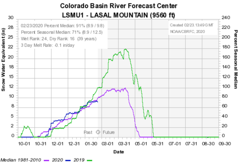
The SE Utah region is still over 100%.


Avalanche Problem #1
Wind Drifted Snow
Type
Location
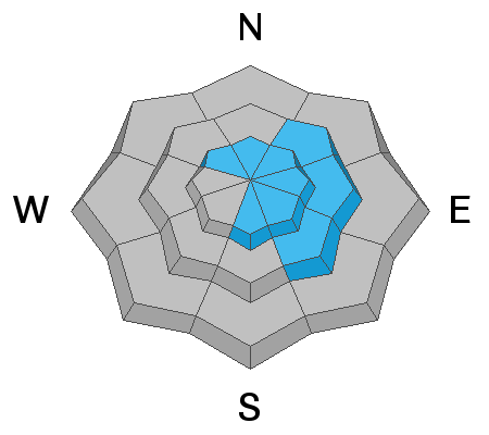
Likelihood
Size
Description
Moderate to strong NW winds overnight have blown and drifted the new snow, as well as whatever loose snow was available for transport. Be on the lookout today for fresh, unstable drifts on the leeward sides of ridge crests and terrain features in wind-exposed terrain. Though winds are northwesterly, cross-loading could still be a factor on these aspects. Fresh drifts should be mostly shallow, but they could be sensitive where they are overlying loose, recrystallized snow. Be aware of consequences as even a shallow wind slab could sweep you off your feet and take you for a nasty ride into trees or over rocks and cliffs.
General Announcements
My radio interview on KZMU about the history of backcountry skiing in the La Sals, avalanche accidents, and unique snowpack has been saved in perpetuity. You can listen to it here.
Check out the avalanche beacon training park at the Geyser Pass Trailhead and practice your rescue skills!
This forecast is from the U.S. Forest Service, which is solely responsible for its content. This forecast describes general avalanche conditions and local variations always occur.