

Forecast for the Moab Area Mountains

Issued by Eric Trenbeath on
Friday morning, February 14, 2020
Friday morning, February 14, 2020
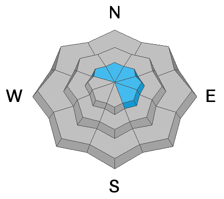
The avalanche danger is generally LOW and mostly stable snow conditions exist. That said, it may still be possible to trigger an avalanche in isolated areas with very steep, rocky, extreme terrain, primarily on slopes with a N-E-SE aspect. Even a small avalanche triggered in the wrong terrain can have devastating consequences. Slide for life conditions also exist where the snow surface is firm and hard. If you are out bagging peaks, carry a means for self-arrest such as an ice axe, or whippet. Crampons may also be desirable.
Low
Moderate
Considerable
High
Extreme
Learn how to read the forecast here
 Special Announcements
Are you looking to improve your avalanche skills? We are offering a Backcountry 101: Introduction to Avalanches class on February 15-16 in Moab. Click here to register A huge thanks to Moab Gear Trader for sponsoring this course. Please visit them for all your winter backcountry needs.
Road Conditions: The road is plowed but snowpacked and icy in places. Thanks Grand County!
Grooming report: LUNA (Lower Utah Nordic Alliance) groomed the lower meadow and into Gold Basin on Wednesday. Thanks Gerrish!
 Weather and Snow
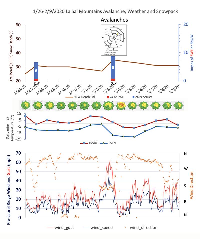
24 Hour Snow 0" Weekly Snow 1" Base Depth in Gold Basin 47" Wind SW 10-20 G30 mph Temp 22F
Weather: Look for more sunny skies today with light to moderate SW winds, and high temps in the mid 30's. Conditions will remain dry through Saturday with the Sunday-Monday storm starting to look like all the rest.
Snowpack: The past several weeks have not been good for our snowpack. On the surface, SW-NW winds have strafed and scoured the snow right down to the rocks at upper elevations. Where snow still exists in these areas it looks like a textured desert landscape. Ribbons of windboard and crust exist on exposed northerly aspects with only the most sheltered of locations offering soft snow. Underneath, weak, sugary, faceted snow has developed in shallower snowpack areas. Though not currently a huge issue this will provide an unstable base for future snow loads should they ever come.
Wind, temperature, humidity on Pre Laurel Peak (11,700')
Storm totals at Gold Basin Study Plot (10,000').
Snotel site near Geyser Pass Trailhead (9600').
NWS weather forecast
Aerial observer, Chris Benson was out flying around taking pictures on Tuesday of our wind ravaged snowpack. Read his observation and see more pictures here.

Chris Benson photo.

Avalanche Problem #1
Normal Caution
Type
Location
Likelihood
Size
Description
Though the danger is generally LOW, I'm sure there are isolated areas out there where you could still trigger an avalanche. With a wide variety of terrain nuances and heavy exposure to wind, there will almost always be an isolated wind slab lurking about somewhere at upper elevations in these mountains. In some areas, these wind slabs may be overlying weak, sugary, faceted snow. Suspect areas of snow that sound or feel hollow like a drum.
The distinction in arriving at LOW danger is in the size (small), likelihood (not very), and distribution (isolated), of these particular avalanche problems. You can minimize your exposure by avoiding rocky, extreme terrain steeper than about 40 degrees. Steep, wooded chutes just below treeline are also potentially dangerous places. In these areas, the snowpack is shallower, and weak, faceted snow has developed. Practice safe travel techniques with an eye toward subtle terrain features if you are moving into larger, or more extreme terrain.
Additional Information
Local observer, and environmental sedimentologist Chris Benson, has prepared these charts to track avalanche, weather, and snowpack data over the past 2 weeks. It's a great way to see the history of what's been going on up there, and how weather events correspond to the daily danger rating. Snow data is from the Snotel site at the Geyser Pass Trailhead at 9600'. This site receives considerably less snow than the Gold Basin plot at 10,000', but it also measures Snow Water Equivalent (SWE), or water weight within the snow. This measurement is far more important to avalanche forecasters than snow amounts. Thanks Chris!
General Announcements
My radio interview on KZMU about the history of backcountry skiing in the La Sals, avalanche accidents, and unique snowpack has been saved in perpetuity. You can listen to it here.
Check out the avalanche beacon training park at the Geyser Pass Trailhead and practice your rescue skills!
This forecast is from the U.S. Forest Service, which is solely responsible for its content. This forecast describes general avalanche conditions and local variations always occur.