


Forecast for the Moab Area Mountains

Issued by Eric Trenbeath on
Thursday morning, February 6, 2020
Thursday morning, February 6, 2020
Today there is a MODERATE danger for human triggered avalanches involving recent deposits of wind drifted snow. That said, there are many steep, wind drifted slopes out there that I would consider a no-go right now. The danger is greatest on upper elevation slopes facing N-NE-E but any wind loaded slope should be considered suspect. NW winds today may also form some sensitive new drifts on southerly aspects. Choose terrain carefully and avoid steep slopes with recent deposits of wind drifted snow.

Low
Moderate
Considerable
High
Extreme
Learn how to read the forecast here
 Special Announcements
Are you looking to improve your avalanche skills? We are offering a Backcountry 101: Introduction to Avalanches class on February 15-16 in Moab. Click here to register A huge thanks to Moab Gear Trader for sponsoring this course. Please visit them for all your winter backcountry needs.
Road Conditions: Grand County has plowed and widened the road.
Grooming report: LUNA (Lower Utah Nordic Alliance) groomed yesterday.
 Weather and Snow
24 Hour Snow T" Weekly Snow 10" Base Depth in Gold Basin 52" Wind NW 20-25 G 35 mph Temp 14F
Weather: NW ridgetop winds blew in the 20 -25 mph range with gusts into the 40's most of the day yesterday. Under mostly cloudy skies they'll continue to be blustery today. A chance of snow is possible as a storm system tracks by to the north. Dry conditions follow through Saturday with the next system moving in on Sunday.
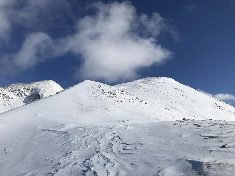
Snowpack: Chris Jacobsen and I took a spin over to the east side of the range on Tuesday and found considerably less snow over there with only 3"-5" new from Monday's storm. Reports from a party at the Geyser Pass Yurt are of around 6" of new snow up there. Gold Basin and the Geyser Pass Trailhead appear to have been at the epicenter of the storm. Brian Hays went up Laurel Wednesday and reported 8"-10" of new with good turning in sheltered terrain, with variable and wind-blasted conditions in exposed areas. Evan Clapper made it over to Gold Knob yesterday and sent in this observation.
Underneath, the snowpack is taking the form of a mid-season continental snowpack on an average year, with varying depths and strengths minus the depth hoar. In most areas above about 10,500', the pack is deep and strong with a depth of 4'-5'. But sun and wind-exposed slopes, and rocky areas right around treeline and below have shallower and weaker snow. In most cases, these weaker snow areas are not yet a problem. Isolated concerns exist in areas of steep, rocky, or sparsely wooded extreme terrain where wind drifted snow has been added to the underlying weak snow.
Wind, temperature, humidity on Pre Laurel Peak (11,700')
Storm totals at Gold Basin Study Plot (10,000').
Snotel site near Geyser Pass Trailhead (9600').
NWS weather forecast
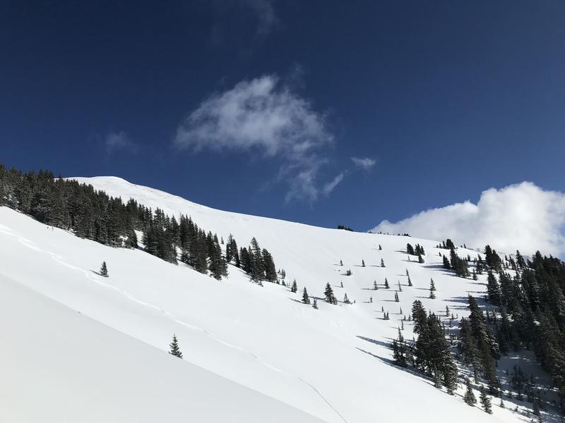
In wind exposed terrain above treeline expect to find scoured surfaces, but drop down just a bit and you'll be rewarded. Brian Hays photos.
 Recent Avalanches
Our repeat running favorite in Tele Gold pulled out again sometime during the storm. For details see this report from Brian Hays.

Avalanche Problem #1
Wind Drifted Snow
Type
Location
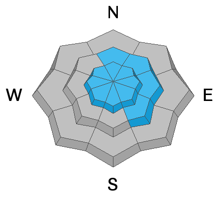
Likelihood
Size
Description
Human triggered avalanches involving recent deposits of wind drifted snow are your primary concern today and there are many steep, wind drifted slopes out there that I would consider a no-go right now. The danger is greatest on upper elevation slopes facing N-NE-E but any wind loaded slope should be considered suspect. NW winds today may also form some sensitive new drifts on southerly aspects. Recent drifts are recognizable by their smooth, rounded appearance and cracking is a sign of instability. Choose terrain carefully and avoid steep slopes with recent deposits of wind drifted snow.
Avalanche Problem #2
Persistent Weak Layer
Type
Location
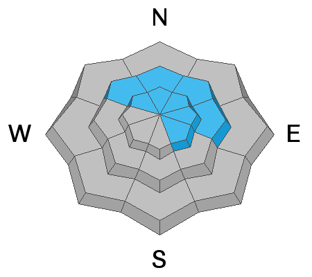
Likelihood
Size
Description
We've been seeing some cracks develop in our generally strong snowpack, particularly in our mid-elevation band just below treeline. In these areas, the snowpack is shallower, between 3'-4' deep, and layers of weak faceted snow are beginning to develop. This storm, with an inch of water weight, is the second incremental test of these buried weak layers. Add drifting and the load may be significant enough for a skier or rider to trigger a deeper and more dangerous avalanche in areas of more extreme terrain. Avoid steep, wind drifted slopes, especially in areas where you suspect the underlying snowpack is shallow and weak.
We've also been tracking a reactive weak layer on SE-S facing slopes. I'm hoping the warm temps over the weekend have helped put an end to this concern but I still don't have enough information about this to be certain.
General Announcements
My radio interview on KZMU about the history of backcountry skiing in the La Sals, avalanche accidents, and unique snowpack has been saved in perpetuity. You can listen to it here.
Check out the avalanche beacon training park at the Geyser Pass Trailhead and practice your rescue skills!
This forecast is from the U.S. Forest Service, which is solely responsible for its content. This forecast describes general avalanche conditions and local variations always occur.