Forecast for the Abajos Area Mountains

Issued by Eric Trenbeath on
Wednesday morning, January 29, 2020
Wednesday morning, January 29, 2020
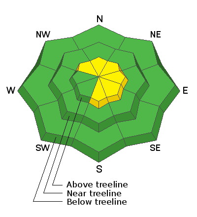
Recent wind drifts have formed as a result of Monday's storm and the avalanche danger is MODERATE on steep, wind drifted slopes. Increasing northerly winds will continue to blow and drift snow today. Areas of unstable wind drifted snow are most likely to be found on upper elevation slopes that face NW-E-S. There is also a MODERATE danger for triggering an avalanche on a buried persistent weak layer, particularly on wind loaded slopes that face S-SE. Other outlying areas of concern include steep, rocky, northerly facing terrain that has a shallow snowpack.

Low
Moderate
Considerable
High
Extreme
Learn how to read the forecast here
 Special Announcements
Are you looking to improve your avalanche skills? We are offering a Backcountry 101: Introduction to Avalanches class on February 15-16 in Moab. Click here to register. A huge thanks to Moab Gear Trader for sponsoring this course. Please visit them for all your winter backcountry needs.
New UAC Podcast: The Art of Storytelling Through Film - A Conversation with Trent Meisenheimer check it out HERE.
 Weather and Snow
Snow totals from Monday's quick-hitting storm ranged from 3"- 6" and conditions yesterday were much better than I expected. Unfortunately, after a mostly calm day yesterday, NW winds bumped up early this morning into the 20-25 mph range with gusts to near 30. Skies are mostly cloudy as a weak system blows through the area bringing with it a slight chance for snow. Once it moves on, we should see mostly sunny skies later today with continued blustery, northerly winds, and high temps in the mid 20's. Another weak system will blow through on Thursday night with high pressure moving in Friday.
Kevin Dressel was up Monday and reported blustery conditions with a fair amount of blowing snow. He also reported finding good conditions in sheltered areas. Read his report here.
Today you will want to be alert to unstable areas of wind drifted snow, particularly on the leeward sides of ridge crests and terrain features. Suspect smooth rounded looking pillows or areas that feel hollow underneath. Cracking is a sign of instability. For safety and snow quality, stick to sheltered locations.
Kevin shot this clip of yesterday's winds transporting snow. Wind drifted snow is a sign of increasing danger and potentially unstable avalanche conditions.
Snow totals at Buckboard Flat (8924')
Snow totals at Camp Jackson (8858')
Wind, temperature, and humidity on Abajo Peak (11,000')
 Recent Avalanches
General Announcements
This forecast is from the U.S. Forest Service, which is solely responsible for its content. This forecast describes general avalanche conditions and local variations always occur.


