Forecast for the Abajos Area Mountains

Issued by Eric Trenbeath on
Tuesday morning, January 28, 2020
Tuesday morning, January 28, 2020
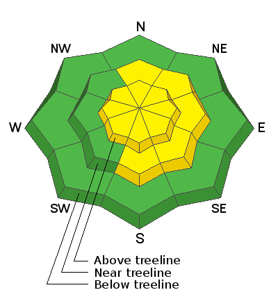
Unstable areas of wind drifted snow continue to be our primary concern and the avalanche danger is MODERATE. Steep, wind drifted slopes right around treeline and above that face N-NE-SE are the most likely areas for you to trigger an avalanche but unstable drifts may be found on all aspects at upper elevations. A triggered wind slab also has the potential to break into a buried persistent weak layer causing a deeper, and more dangerous avalanche. Areas of steep, rocky, more radical terrain are where you are most likely to find this problem.

Low
Moderate
Considerable
High
Extreme
Learn how to read the forecast here
 Special Announcements
Are you looking to improve your avalanche skills? We are offering a Backcountry 101: Introduction to Avalanches class on February 15-16 in Moab. Click here to register. A huge thanks to Moab Gear Trader for sponsoring this course. Please visit them for all your winter backcountry needs.
New UAC Podcast: The Art of Storytelling Through Film - A Conversation with Trent Meisenheimer check it out HERE.
 Weather and Snow
The mountains picked up 3"-6" of new snow from yesterday's quick hitting system . Unfortunately, NW winds blew solidly for the past 24 hours in the 15-20 mph range with gusts to near 30. Today look for mostly sunny skies in the mountains this morning. Northerly winds will blow in the 10-15 mph range, and high temps will rise to the mid and upper 20's. We should see increasing clouds today ahead of a weak system that will take a dive far to the south of us. Dry conditions are on tap for the rest of the week and into the weekend.
Kevin Dressel was up yesterday and reported blustery conditions with a fair amount of blowing snow. He also reported finding good conditions in sheltered areas. Read his report here.
Today you will want to be alert to unstable areas of wind drifted snow, particularly on the leeward sides of ridge crests and terrain features. Suspect smooth rounded looking pillows or areas that feel hollow underneath. Cracking is a sign of instability. For safety and snow quality, stick to sheltered locations.
Kevin shot this clip of yesterday's winds transporting snow. Wind drifted snow is a sign of increasing danger and potentially unstable avalanche conditions.
Snow totals at Buckboard Flat (8924')
Snow totals at Camp Jackson (8858')
Wind, temperature, and humidity on Abajo Peak (11,000')
 Recent Avalanches
General Announcements
This forecast is from the U.S. Forest Service, which is solely responsible for its content. This forecast describes general avalanche conditions and local variations always occur.


