Forecast for the Provo Area Mountains

Drew Hardesty
Issued by Drew Hardesty on
Sunday morning, December 8, 2019
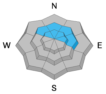
Areas of CONSIDERABLE danger exist on mid and upper elevation aspects facing northwest, through north, and east where a persistent weak layer of snow buried down 2-3' exists. If the higher end of snow totals verify, the danger will rise to MODERATE for storm snow and wind slabs on a variety of aspects.
Low
Moderate
Considerable
High
Extreme
Learn how to read the forecast here
Special Announcements
Thanks to the generous support of our Utah ski resorts and Ski Utah, we have discount lift tickets available. All proceeds from these go towards paying for avalanche forecasting and education! Get your tickets HERE.

Get one of these cool t-shirts to support the UAC and other avalanche centers across the U.S. INFO
Weather and Snow
As of 5am, a light rain/snow mix blankets the Provo mountains with snow-water-equivalents of 0.44" so far. This likely translates to 3-4" of snow at the highest elevations. Winds are from the west and southwest blowing 17mph gusting to 25 and mountain temps are in the low 30s but falling. We should see 3-6" of more snow through tomorrow. We'll see a break Tues/early Wed before a cold front Wed eve and a series of westerlies Thurs through the weekend.
Recent Avalanches
None.
Ad
Avalanche Problem #1
Persistent Weak Layer
Type
Location
Likelihood
Size
Description
We've had no reports from the upper elevations of the Provo area mountains but extrapolate that mid and upper elevation snow structure is poor and potentially unstable on steep northwest to easterly facing slopes. The Thanksgiving storms are now a thick slab overlying weak old snow from October and this structure continue to cause avalanches in the Salt lake mountains. Extra caution is warranted in steep shady terrain. Extra snow and wind today will add additional stress to this tenuous snowpack.
Avalanche Problem #2
New Snow
Type
Location
Likelihood
Size
Description
While it appears that wind, sun, and warmth has jettisoned, if not degraded, the previous weak snow surfaces, this morning's graupel may instead act as a weak layer that sits on a variety of hard sun and wind crusts. Today, target your inquiry to see how sensitive the storm snow is as it slowly adds up in the mountains. Test slopes and quick hand pits often provide some clue to the situation. Shooting cracks also provide evidence. If we see the higher end of snow totals, it should be possible to trigger new storm snow avalanches on a variety of aspects.
Additional Information
With sun and warming, shallow wet push-alanches and rollerballs are likely on steep sunny slopes.
Consider signing up for a companion rescue course!